
What is recorded here
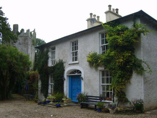
Detached three-bay two-storey farmhouse, extant 1887, on an L-shaped plan; single-bay (north) or four-bay (south) two-storey side elevations. Disused, 2007. Hipped slate roof on an L-shaped plan with clay ridge tiles, paired cement rendered central chimney stacks having concrete capping supporting yellow terracotta octagonal pots, and cast-iron rainwater goods on slate flagged eaves retaining cast-iron downpipes. Part creeper- or ivy-covered roughcast walls bellcast over rendered plinth with rendered strips to corners. Segmental-headed central door opening with step threshold, and rendered surround centred on keystone framing timber panelled door having fanlight. Square-headed window openings with cut-granite sills, and concealed dressings framing six-over-six timber sash windows. Set in unkempt grounds with limewashed rendered cylindrical piers to "cottage garden" having domed capping supporting looped wrought iron gate.
A farmhouse representing an integral component of the nineteenth-century domestic built heritage of Baldwinstown with the architectural value of the composition suggested by such attributes as the symmetrical frontage centred on a restrained doorcase showing a simple hub-and-spoke fanlight; and the slight diminishing in scale of the widely spaced openings on each floor producing a feint graduated visual impression. Having been well maintained, the form and massing survive intact together with substantial quantities of the original fabric, both to the exterior and to the interior, thus upholding the character or integrity of the composition. Furthermore, adjacent outbuildings (----) continue to contribute positively to the group and setting values of a self-contained ensemble having historic connections with the Stafford family including John Stafford (d. 1878) 'late of Baldwinstown County Wexford' (Calendars of Wills and Administrations 1878, 672); and Nicholas Stafford (1852-1935).
This does not grant access. Most recorded buildings are privately owned; view them only from public ground unless the owner allows entry.
Places near here
 Enclosure in BaldwinstownEnclosure · 213 yd
 Chapel & Burial Ground (Site of)Church · 305 yd
 Castle Housefarm house · 634 yd
 Driseógfarm house · 644 yd
 Brideswell Ho.Castle, unclassified · 1426 yd
 Castle (in ruins)Castle, tower house · 1435 yd
 Cull IslandIsland · 3.6 mi
 Carrickatinna RockMountain / peak · 3.9 mi
 The Heron's MeadowForest · 3.9 mi
 The Bull RockForest · 4.0 mi
 Skeater RockMountain / peak · 4.0 mi
 1798 Memorial PlaqueMemorial · 4.0 mi
Other information
Photo: National Inventory of Architectural Heritage · Website use allowed for educational or private purposes with source credit