Overview
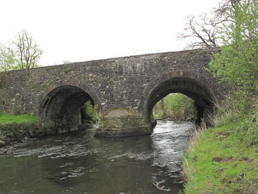
Anlore Bridge is recorded as bridge in Monaghan. Two-arched bridge, built c.1720, widened c.1800 and again c.1850. Round arches to north elevation, with tooled stone voussoirs, gauged masonry round arch to earlier section and gauged masonry pointed arch to south elevation, with gunnelled soffits.
Why it was built
The saved account records: Two-arched bridge, built c.1720, widened c.1800 and again c.1850.
People and work
The saved account records: Round arches to north elevation, with tooled stone voussoirs, gauged masonry round arch to earlier section and gauged masonry pointed arch to south elevation, with gunnelled soffits.
How it changed
The saved account records: Coursed rubble stone walls to spandrels and parapets.
What survives
The saved account records: West of parapet wall to south elevation rendered, having render capping.
Why it mattered
Anlore Bridge matters for the exact reasons given in its official assessment, rather than merely because it is an old structure. The source records: This bridge was built in a number of phases, as is evidenced by the varying levels of soffits and shapes of the arch rings. These traces of adaptation and change add an important patina of age to the site. It may have been built in conjunction with the adjacent corn mill, which itself was rebuilt on a number of occasions throughout the eighteenth and nineteenth centuries. The bridge provides an important transport link and is indicative of the early improvements in the transport network from the eighteenth century. This explains what the place adds to local life, the street or the surviving built history.
History checked 15 August 2026 against the named sources below.
Places near here
- mill (water) — ANNAGHKILLYbuildingunder 0.1 miles
- Common Lime — Analore, Co. Monaghanforestunder 0.1 miles
- Ancient Stone (Site of) — Annaghkillymonumentunder 0.1 miles
- Indicated — Killycoonaghmonument0.2 miles
- Killycoonaghforest0.2 miles
- Killycoonagh House — Anlorebuilding0.2 miles
- Saint John's Wellwaterfall0.2 miles
- Mapped graveyard — County Monaghanmemorial0.2 miles
- Graveyard (Disused) — Annaghkillymonument0.3 miles
- Church in Annaghkillymonument0.3 miles
- Annaghkilly National School — Anlorebuilding0.3 miles
- Ballynure House — Anlorebuilding0.4 miles
Add the human story, a picture, a first-hand message or a missing place.
Earn 5 points after the picture is checked and accepted.
Add a pictureAdd its storyTalk or ask a questionAdd a new placeThis official record and map point do not grant access. Most recorded buildings are privately owned; view them only from public ground unless the owner allows entry.
Conversation about this place
Questions and messages sit beneath the source record. They are checked before appearing.
No questions or messages yet.
Ask a question or join the conversation