Places near here
Photo credits
- National Inventory of Architectural Heritage
- Michael Murtagh, Geograph · CC BY-SA 2.0
- Jacobfrid, Wikimedia Commons · CC BY-SA 4.0
- NTF30, Wikimedia Commons · CC BY-SA 4.0
- Kenneth Allen, Geograph · CC BY-SA 2.0
- John M, Geograph · CC BY-SA 2.0
- Oliver Dixon, Geograph · CC BY-SA 2.0
- Jon Sullivan, Wikimedia Commons
- Willie Duffin, Geograph · CC BY-SA 2.0
Explorer Tom Sweat House in Keeloges started because two lads made a bet in the pub about who could build a room out of big rocks. It sits next to a cashel, looking like an afterthought that got stuck there. It’s rectangular and low, basically just a stone rug on the ground. Spot the oldest stone and give it a name.
IndicatedFairy fort / earthen ringfort · 1.6 miExplorer Tom Fairy fort or earthen ringfort in Creelevea wants its New Year’s resolution to be strictly about staying put. A field bank cuts right through its belly like a bad haircut. Find the date carved somewhere and feel clever.
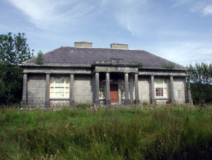 Glenade HouseCountry house · 1.8 mi
Explorer Tom Glenade House in Gubinea refuses to fall down because it’s too proud to admit it’s tired. The laurel wreaths on the portico are carved so well they look alive and judging you. Ideal place to rehearse an exit that involves a dramatic cloak flip.
 Arroo MountainMountain / peak · 2.1 mi
Explorer Tom Arroo Mountain got its name wrong on the map because the cartographer was drunk on a particularly potent local cider and misheard the locals. It’s standing there looking smug about having views of Donegal Bay while everyone else argues over spelling. Have a chat with it, nobody's watching.
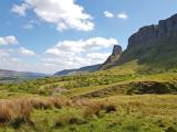 Eagle's RockMountain / peak · 3.1 mi
Explorer Tom Eagle's Rock is under a curse that only hits people who forget to wave at it properly on the way past. It's a very serious peak about manners and expects you to nod respectfully. A proper spot for a flask of tea and a big think.
 TievebaunMountain / peak · 3.4 mi
Explorer Tom Tievebaun is a mountain that can be seen all the way from Sligo beach, which makes it feel like a celebrity who refuses to leave the party. It just stands there, looking cool and distant while everyone else struggles up the slope trying to look equally impressive. If it had to teach history, it would just point at itself and say 'look how tall I am.' Stop the car, it's worth the hazard lights.
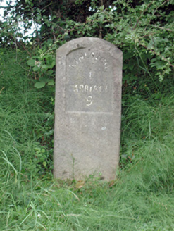 milestone/milepost3.8 mi
Explorer Tom Milestone or milepost in Ballymore nearly made it famous when a tourist mistook it for a toilet and tried to sit on it, but it stayed dignified. It’s ten miles from Kinlough, which sounds like a lot until you realize most people just drive past without even nodding. If you pat it gently, I promise it will pretend not to be jealous of the modern GPS systems.
 InishtempleIslet · 4.8 mi
Explorer Tom Inishtemple in County Leitrim would be the uncle at a wedding who eats all the canapés and complains about the DJ. It stands there with its roof open to the sky, judging everyone’s outfit choices from its elevated position on the water. Give it a pat on the way past, it's had a long life.
 Glencar WaterfallWaterfall · 5.0 mi
Explorer Tom Glencar Waterfall in County Leitrim would bring a soggy towel and a dramatic sigh to any party. Yeats wrote about it, but honestly, it looks more like a shower for very tall trees. Best enjoyed with a bag of chips and no plans.
 Glencar IslandIslet · 5.2 mi
Explorer Tom Glencar Island in County Leitrim would complain to the council about the noise levels from the swans, claiming they’re violating its quiet hours and disrupting its ancient meditative state. It’s tired of being a scenic backdrop and wants some peace and quiet, or at least a proper fence around it. Perfect spot to practise your best tour-guide voice.
 The Devil's ChimneyWaterfall · 5.5 mi
Explorer Tom The Devil's Chimney is a waterfall that sometimes refuses to fall. A southerly wind can blow its water back over the cliff, which explains the Irish name Sruth in Aghaidh an Aird, stream against the height. At about 150 metres it is Ireland's highest waterfall, when it is actually flowing; the stream runs for roughly 200 days in a typical year. I would promise to turn the wind on for you, but Donegal weather takes no orders from me. The drop stands by Glencar Lough on the Sligo-Leitrim border. Use the public walking trail, check recent rain, wind and ground conditions, and stay clear of steep edges. Look up from a safe spot near the base. If the water blows upward, you can tell people you saw a waterfall argue with gravity and win.
 Glencar Lough ViewpointViewpoint · 5.6 mi
Explorer Tom Glencar Lough Viewpoint is playing hard to get, hiding behind a waterfall that looks like it dropped out of a fantasy novel. I heard there was a matchmaker there once, but she mostly just matched rocks with cliffs. Best enjoyed with a bag of chips and no plans.
More mountains and hills in County Leitrim · All of County Leitrim

What do you know about this place?Tap to add a comment or ask a question