DDiscover AloneMapAbout

Abbey in Ballypheasan

Religious house, Dominican friars
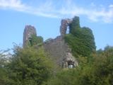
Abbey in Ballypheasan
Photo: 瑞丽江的河水, Wikimedia Commons · CC BY-SA 4.0 · Report the wrong picture

What is recorded here

A Dominican friary was established by Felimid O'Conor in 1253. It was burned in 1270 and struck by lightning in 1308. By 1445 it was in disrepair when an indulgence was granted to restore its fabric, and in 1578 it was granted to Sir Nicholas Malby. In 1615 the friary was granted to Francis Viscount Valentia, but it…

Read the whole record
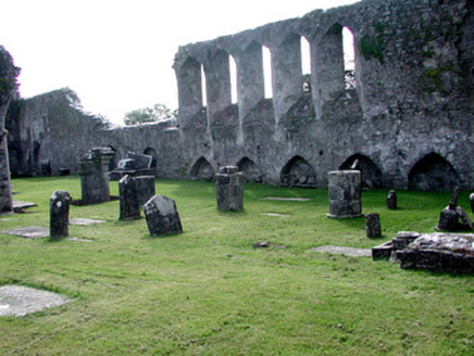
A Dominican friary was established by Felimid O'Conor in 1253. It was burned in 1270 and struck by lightning in 1308. By 1445 it was in disrepair when an indulgence was granted to restore its fabric, and in 1578 it was granted to Sir Nicholas Malby. In 1615 the friary was granted to Francis Viscount Valentia, but it had been described as in ruins in 1612. It is situated on a slight rise in a low-lying landscape. (Gwynn and Hadcock 1980, 229) The remains consist of a nave and chancel church (int. dims 40m E-W; 6.8m N-S) entered through a modern entrance in the W gable. There is a N aisle (int. dims 22.8m E-W; 3.3m N-S), now represented by three circular piers separating it from the nave. A N transept (int. dims 6.6m E-W; 5.4m N-S) with a three-light N window, now robbed, was added to the E end of the N aisle in the 15th century, at which time a tower was put over the chancel, of which only the bases of the S piers survive. The E window of the chancel, originally of three lancets, was replaced with a five-light tracery window, now robbed, and the W window, originally of three lancets, was replaced with a four-light tracery window, now robbed. There were six lancets on the S nave wall, placed above the cloister roof, and at least four on the N chancel wall, while doorways on the S wall led to a sacristy and the cloister, of which nothing remains. Beneath the lancet windows on the inner face of the S nave wall there are six recesses (Wth 1.8m; H c. 1m; D 0.4m), one of which has a piece of painted decoration. An effigy (RO039-055004-), said to be that of Felimid O'Conor and made c. 1290-1300, is in the niche of a 15th wall monument (RO039-055003-) with eight warriors from its chest surviving in the N chancel wall (O'Gorman 1866; Taylor 1892-4a; FitzGerald 1892-4; FitzGerald 1900; Hunt 1974, 216-18, No. 213). A fragment with two panels from another tomb (RO039-055006-) is no longer present (Hunt, 1974, 1, 217, No. 214) and the 17th century memorial of John Hynde (RO039-055011-) recorded by FitzGerald at the W end of the church (1893, 357) is also missing. A limestone graveslab (RO039-055005-) (dims 1.25m x 0.91m) of John Verdon with the date 1656 is on the ground beside the O'Conor effigy. A sculpted stone (RO039-055009-) (Wth c. 0.44m; H c. 0.33m) with a carving of two entwined beasts is set in the coping around the O’Conor tomb (Siggins 1994), and the bases of two graveslabs (RO039-055007-; RO039-055008-) (Bradley and Dunne 1988, 104) have been re-identified recently by Garry Dempsey. One (L 0.8m; Wth 0.5m; T 0.16m) is outside the W wall of the N chancel and has a moulding on the edge and the incised double line of the stem of a cross is visible at the broken end. Another (L 0.48m; Wth 0.44m; T 0.29m) in the SE angle of the church has a moulded edge but no device on its upper surface can be detected. A fragment of what might be a graveslab is cut into a square piece (L c. 1.2m; Wth 0.32m; T 0.08-0.13m) and incorporated into the coping around the O’Conor tomb (RO039-055003-). It was recently identified by Brian Shanahan and recorded by Gary Dempsey. It has a raised band, probably from the stem of a cross, down the centre that bifurcates at one end. A raised image of what might be a cat with a small animal in its mouth overlies the stem. Archaeological testing (98E0438) c. 120m S of the abbey (FitzPatrick 2000a; Nelis 2000) and just to its W (01E1211) (Halpin 2003) failed to produce any related archaeological evidence. Further testing (04E1565) c. 100m to the NW had similar results (Byrne 2007). Test excavations (E004027) in 2009 in the garden c. 40m to the S on foot of a geophysical survey demonstrated that the features recorded were late 19th century or later in date (Henry 2009, 2012). (Bradley and Dunne 1985, 100-04) See the attached external images from NE (001) and SSW (002), and the internal view looking E (003) Compiled by: Michael Moore Date of revised upload: 25 June 2015 This monument is subject to a preservation order made under the National Monuments Acts 1930 to 2014 (PO no. 3/1931), and is now a National Monument in state ownership: No. 362

From the National Monuments Service (Archaeological Survey of Ireland) record RO039-055001

The monument record does not grant public access. Check the route and ask the landowner before entering private land.

What do you know about this place?Tap to add a comment or ask a question

What you write will be public.

Places near here

Photo credits
  • National Inventory of Architectural Heritage
  • Darrin Antrobus, Geograph · CC BY-SA 2.0
  • Irishrover1980, Wikimedia Commons · CC BY-SA 4.0
  • Algirdas at Lithuanian Wikipedia, Wikimedia Commons · Public domain
  • Sitomon, Wikimedia Commons · CC BY-SA 2.0
  • Sarah777 at en.wikipedia, Wikimedia Commons · Public domain
  • Mike Searle, Geograph · CC BY-SA 2.0
  • AmandaMcCrann, Wikimedia Commons · CC BY-SA 4.0
  • Mike Searle, Wikimedia Commons · CC BY-SA 2.0
  • Arno-nl, Wikimedia Commons · CC BY-SA 4.0
  • Christopher Hilton, Wikimedia Commons · CC BY-SA 2.0
graveyard/cemetery5 yd

Explorer Tom Graveyard or cemetery in Ballypheasan is where the dead stopped paying rent in 1912 because St Coman's offered better amenities. The stones are fancy, but they're all just sitting there pretending to be important while the abbey ruins behind them gather moss. Don't stare too long, or they'll start judging your footwear.

The AbbeyHouse · 144 yd

Explorer Tom The Abbey in Ballypheasan is having a rivalry with the real Abbey ruins nearby, insisting that its turrets are far more impressive than their crumbling walls. It’s a mini Gothic castle that looks like it got lost on the way to a medieval theme park and decided to stay for dinner. Wave at the parapet; it might just throw a pebble.
Roscommon CastleCastle · 1302 yd

Explorer Tom Roscommon Castle in County Roscommon would explain the 1800s to a teenager by saying, 'Imagine your mum's house, but with more damp and fewer Wi-Fi signals.' It’s been sitting there judging everyone since before we had proper trousers, still looking mighty smug about it. Go now, before it gets famous.
Pedunculate Oak2.2 mi

Explorer Tom Pedunculate Oak in County Roscommon is deeply suspicious of the postman and probably thinks he’s stealing its acorns every single morning. It’s got this grumpy old man energy that makes you want to tip your hat as you pass by. Find a local and ask them the real story, then come back and tell me.
European Yew4.1 mi

Explorer Tom European Yew in County Roscommon had a cow try to buy it once, which is either genius or absolute madness. The tree just stood there looking unimpressed while the farmer argued about the price of such an ancient specimen. Bring a jacket, it's never as warm as I promise.

Stone sculptureStone sculpture, aniconic · 4.2 mi

Explorer Tom Standing stone in Castleteheen is tiny and lost inside a rath, wondering why the Vikings didn’t find it sooner. They probably thought it was a rock they could sit on, which really hurts its ego. Snap one photo, then put the phone away and actually look.

CastleHouse, fortified house · 4.7 mi

Explorer Tom Castle in Toberavaddy holds the fake world record for the most awkward L-shaped architecture ever attempted. Edward Ormsby owned it, but I doubt he knew what to do with all that extra corner. Tell it a joke, it's been a long time since anyone did.

Hangman's HillMountain / peak · 5.1 mi

Explorer Tom Hangman's Hill is in a bitter feud with the next village over who stole their best scarecrow last summer. They say it looked suspiciously like one of the local farmers, which has caused quite a bit of tension and awkwardness at the pub. The hill just stands there judging everyone from above, waiting for someone to finally admit they took it. Go on a wet day

IndicatedRound tower · 7.0 mi

Explorer Tom Round tower in Carroweighter is constantly losing a rivalry with the ones in Kildare, which are way too showy for their own good. It stands there with its arms crossed, pretending it doesn’t care that everyone else gets the tourists. Count the crows, then count them again to be sure.

Bawn in Glinsk (ballymoe By.)Bawn · 10.0 mi

Explorer Tom Bawn in Glinsk listens to what goes on inside the walls and probably hears the Burkes arguing about who left the light on in 1630. It’s a well-preserved semi-fortified house that looks like it’s judging your posture, so stand up straight or don’t bother knocking. It's free, it's odd, what more do you want?

Safe HarbourBay · 10 mi

Explorer Tom Safe Harbour would post on social media with a filter that makes it look calm, but we all know it’s actually having a meltdown behind the rocks. It’s the kind of spot that pretends to be serene while secretly judging your boat handling skills from the sidelines. A handy spot to stretch your legs and your imagination.
RindoonWood · 10 mi

Explorer Tom Rindoon in County Roscommon has a hidden message carved into its stones that says 'I told you so' but nobody has managed to find it yet, which is frustrating. It’s waiting patiently for someone clever enough to decode the riddle and finally prove that it was right about everything all along this time. Tell it a joke, it's been a long time since anyone did.

More historic places in County Roscommon · All of County Roscommon

Add to this placeAdd a picture Add a detailed tip Add a story

Explore the map1,093,392 places to discover

Next place · or swipegraveyard/cemetery