
What is recorded here
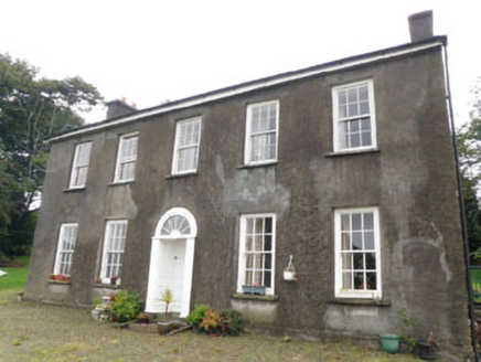
Detached three-bay two-storey worker's house, built c.1820, having recent single-storey extension to rear (west). Currently disused. Pitched artificial slate roof with rendered chimneystacks, platband and eaves course, rainwater goods absent. Lined-and-ruled rendered walls. Square-headed window openings with render sills throughout, having two-over-two pane timber sliding sash windows to front (east) elevation. Square-headed door opening with rendered reveals to front elevation, having timber battened door. Four-bay two-storey rubble stone outbuilding to north, having slate roof with render gable copings. Square-headed openings having battened timber shutters and doors.
Shown on the first edition Ordnance Survey map within the Gortnahorna House demesne, this house would appear to have been built to accommodate an estate work. Set within a field labelled 'paddock' on the map, the related outbuilding adds to its setting and context. Retaining much historic fabric, together they make a notable roadside addition.
From the Buildings of Ireland (National Inventory of Architectural Heritage) record 20912321
This does not grant access. Most recorded buildings are privately owned; view them only from public ground unless the owner allows entry.
Places near here
Photo credits
- National Inventory of Architectural Heritage
- Hywel Williams, Geograph · CC BY-SA 2.0
- John M, Geograph · CC BY-SA 2.0
- Mac McCarron, Geograph · CC BY-SA 2.0
- Jonathan Thacker, Geograph · Creative Commons Attribution-ShareAlike 2.0
- Mike Searle, Geograph · CC BY-SA 2.0
- Maker named on the Wikimedia Commons picture page · Public domain
 Barleyfield BridgeBridge · 398 yd
 Riverdale HouseCountry house · 578 ydSite of Barleyfield Catholic ChapelChurch · 930 ydKilbrittain WoodWood · 1.1 miKilbrittain WhaleHeritage attraction · 1.1 mi
 Trinity WellSpring · 1.5 mi
 Flaxfort StrandBeach / strand · 2.2 mi
 Garranefeen StrandBeach / strand · 2.2 miCrois Na Leanbh MemorialMemorial · 2.4 mi
 Grave YardGraveyard · 4.6 mi
 Castle BernardRuins · 4.8 mi
 English holly4.8 mi
More historic places in County Cork · All of County Cork
What do you know about this place?