
What is recorded here
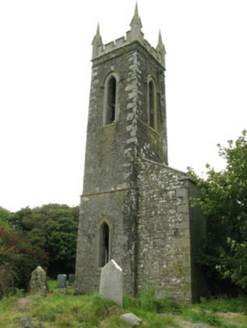
Subrectangular graveyard; headstones date from late 18th century to present day. Contains C of I church (CO136-061002-) on site of earlier church (CO136-105---).
From the National Monuments Service (Archaeological Survey of Ireland) record CO136-061001
The monument record does not grant public access. Check the route and ask the landowner before entering private land.
- What survives
- Recorded monument
Places near here
Photo credits
- Jonathan Thacker, Geograph · CC BY-SA 2.0
- National Inventory of Architectural Heritage
- Steve Edge, Geograph · CC BY-SA 2.0
- Draceane, Wikimedia Commons · CC BY-SA 4.0
- Jean-Pol GRANDMONT, Wikimedia Commons · CC BY 3.0
 Church in LisleetempleChurch · 19 yd
 church/chapel24 ydLislee Court (Site of)Castle, unclassified · 276 ydLislee (Site of)Fairy fort / earthen ringfort · 676 ydHut site in KnockanemeeleenHut site · 738 yd
 Broad StrandBeach / strand · 1077 ydHds walk Coolim CliffsHeritage attraction · 1316 ydBlind StrandBeach / strand · 1364 ydCourtmacsherry Bay ViewViewpoint · 1739 ydWar MemorialMemorial · 1.4 mi
 Chilean myrtle1.5 mi
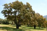 Cork oak1.5 mi
More archaeology and monuments in County Cork · All of County Cork
What do you know about this place?