What is recorded here
Why this person is known: Irish footballer (1865-1932)
Places near here
Picture notes
- National Inventory of Architectural Heritage
- Kenneth Allen, Geograph · CC BY-SA 2.0
- Richard Webb, Geograph · CC BY-SA 2.0
- sarah gallagher, Geograph · CC BY-SA 2.0
- Kenneth Allen, Wikimedia Commons · CC BY-SA 2.0
- louise price, Geograph · CC BY-SA 2.0
- Computer-made picture. It does not show this playground.
- Patrice78500, Wikimedia Commons · CC BY-SA 3.0
- Malene Thyssen, Wikimedia Commons · CC BY-SA 3.0
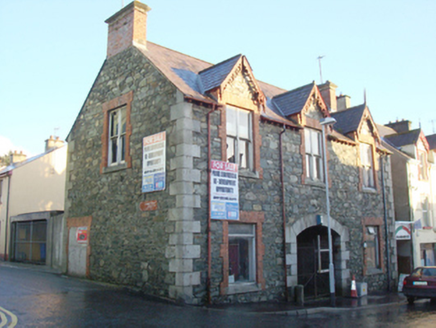 Milford Town HallTown/county hall · 11 yd
Explorer Tom Milford Town Hall was built around 1885 by the Earl of Leitrim and currently sits disused in the middle of town. It’s the perfect place for a picnic on the pavement, just as long as you don’t mind being a little bit historical.
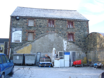 Milford Drapery and InteriorsStore/warehouse · 53 yd
Explorer Tom Milford Drapery and Interiors is a large-scale former warehouse from the late nineteenth century, blending grey dimension stone with red brick surrounds for some textural variation. It retains its natural slate roof and utilitarian character. I bet it sold more tartans than a Highland chief! Go check those bricks.
 The Traveller's InnRestaurant · 64 yd
Explorer Tom The Traveller's Inn is probably hiding a map in the sauce. I bet the chef knows where the lost gold is buried under the fries. Grab a photo of the menu for me!
 WoodquarterForest recreation place · 2.4 mi
Explorer Tom Woodquarter sits by Mulroy Bay where Lord Leitrim got murdered in 1878, adding some spice to the forest planting later on. The trees are just along for the ride now, pretending they didn’t witness the whole bloody mess. Tell me if the gossip I made up is actually true.
 Rough IslandIslet · 2.4 mi
Explorer Tom Another Rough Island in County Donegal, because apparently they needed a sequel to their first act. It sits there looking bored near Mulroy Bay. Ten minutes here and you'll have a yarn for the pub.
 Aghawoney Standing StonesPublicly named standing stone · 2.5 mi
Explorer Tom Aghawoney Standing Stones is a publicly named site in County Donegal. I bet it’s the sort of place where you’d feel a chill, even on a sunny day. It’s a marker of ancient presence that still commands respect.
 Glenalla Standing StoneStanding stone · 3.3 mi
Explorer Tom Glenalla Standing Stone is a 1.4m high monolith with a base width of 1.2m, sitting on the northwest edge of some high ground in rough pasture. It’s quite the sturdy fellow for such a remote spot, standing proud despite its modest dimensions. I reckon it’s been keeping watch over that hillside long enough to have seen every cloud that ever drifted past.
 Children's playground3.6 miComputer-made picture. It does not show this playground.
Explorer Tom Children's playground in County Donegal has a bench that squeaks like a mouse having an existential crisis. I think if you whisper a secret to the slide, it keeps it forever. Tell it a joke, it's been a long time since anyone did anything funny here.
 McGinley'sPub · 3.6 mi
Explorer Tom McGinley's has a guy at the bar who swears he saw a leprechaun pay his tab. He never left. Probably still in the back room polishing glasses that aren't there.
.JPG/250px-Lough_Salt_Mountain_(469m).JPG "Photo: Patrice78500, Wikimedia Commons · CC BY-SA 3.0") Loughsalt MountainMountain / peak · 3.7 mi
Loughsalt MountainMountain / peak · 3.7 miExplorer Tom Right then, we’re heading up Loughsalt Mountain, a proper peak in County Donegal that sits at 469 metres. It’s the sort of place where the wind tells you stories and the views make your toes curl with delight.
 European Beech4.0 mi
Explorer Tom European Beech in County Donegal is just a tree, but make it sound important or people will think you’re wasting time. It’s probably plotting something against the squirrels or the weather. Ten minutes here and you'll have a yarn for the pub, claim you spoke to its roots.
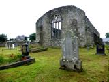 Tullyaughnish Old Church GraveyardGraveyard · 4.1 mi
Explorer Tom Tullyaughnish Old Church Graveyard has been hanging around since 1622, which is basically forever in church years. Sir William Stewart built it, so the locals were definitely keeping up with the trends back then. I bet the ghosts are still complaining about the new church. Take a pic of the old stones!

What do you know about this place?Tap to add a comment or ask a question