What is recorded here
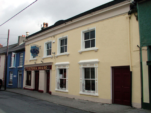
Terraced four-bay two-storey house, c.1820, possibly over basement with square-headed passageway to right ground floor. Extensively renovated, c.1870, with pubfront inserted to left ground floor, and render façade enrichments added. Reroofed, c.1995. Pitched roof behind parapet with replacement artificial slate, c.1995, clay ridge tiles, rendered chimney stacks, and cast-iron rainwater goods. Painted rendered walls with rendered frieze, c.1870, on stringcourse having moulded cornice over, and blocking course to parapet with segmental panel to centre, and urn finials to ends. Square-headed window openings with stone sills (on consoles to first floor), rendered panelled surrounds, c.1870, to ground floor having entablature hoods over, rendered surrounds, c.1870, to first floor, and replacement 2/2 timber sash windows, c.1870, having wrought iron sill guards to ground floor. Square-headed passageway to right ground floor with timber panelled double doors. Rendered pubfront, c.1870, to left ground floor with pilasters, fixed-pane (three-light) timber display window having elliptical heads to panes, wrought iron sill guard, timber panelled door and double doors having overlights, fascia over with raised lettering, and moulded cornice. Road fronted with concrete footpath to front.
A very fine, well-composed middle-size house that has been well maintained to present an early aspect. Of particular interest are the various rendered dressings throughout, including a fine pubfront, which enhance the design quality of the site, and which attest to high quality craftsmanship. The house forms an integral component of the streetscape, and contributes significantly to the visual appeal of Queen’s Street.
From the Buildings of Ireland (National Inventory of Architectural Heritage) record 22816145
This does not grant access. Most recorded buildings are privately owned; view them only from public ground unless the owner allows entry.
Places near here
Photo credits
- P L Chadwick, Geograph · CC BY-SA 2.0
- National Inventory of Architectural Heritage
- Paul O'Farrell, Geograph · CC BY-SA 2.0
- Tmimagery, Wikimedia Commons · CC BY-SA 4.0
- Brendan Tobin, Wikimedia Commons · CC BY-SA 4.0
- Kieran Campbell, Wikimedia Commons · CC BY-SA 2.0
- RTG, Wikimedia Commons · CC BY-SA 4.0
- Philip Halling, Wikimedia Commons · CC BY-SA 2.0
- John M, Geograph · CC BY-SA 2.0
 The CentralHouse · 52 yd
 MarymountHouse · 90 yd
 Doneraile WalkWalking route · 822 yd
 Tramore StrandBeach / strand · 1.4 mi
 Newtown CoveBeach / strand · 1.4 mi
 The Metal ManHeritage attraction · 1.9 mi
 Fenor BogNature reserve · 3.2 mi
 Matthewstown Passage TombArchaeological place · 3.4 mi
 Kilfarrasy BeachBeach / strand · 3.9 mi
 Gaulstown Portal TombArchaeological place · 4.0 mi
 Dunhill CastleCastle · 4.8 mi
 Castle (in ruins)Castle, tower house · 4.8 mi
More historic places in County Waterford · All of County Waterford
What do you know about this place?