What is recorded here
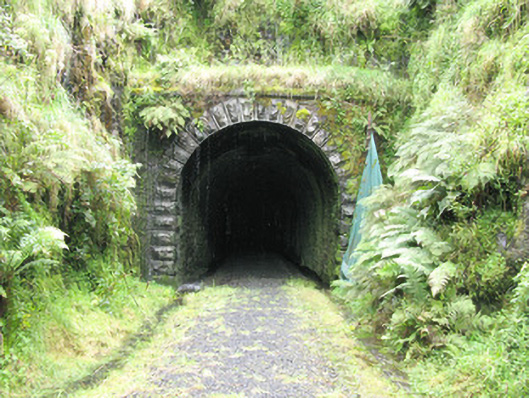
Tunnel in Ballymurragh East lost its trains and acquired nine species of bat. Nine! One bat found a hundred-metre railway tunnel and still couldn’t keep his address from the relations.
Railway tunnel, built c. 1880, having an approximate length of 100 metres with rock cut approach cuttings to sides (east and west). Entrances to side (east, west) elevations having round-headed arches with rusticated limestone voussoirs springing from rusticated limestone piers. Roughly dressed limestone spandrels below roughly dressed limestone parapet walls with rusticated limestone cornice. Snecked roughly dressed stone walls and soffits to interior of tunnel having rubbed red brick voussoirs to crown of arch. Round-headed recesses to internal (north, south) elevations of tunnel having rubbed red brick voussoirs and red brick block-and-start surrounds. Gravel track way leading through tunnel with open water drains to sides (north, south).
This tunnel is one of the more evocative features of the now closed Limerick to Tralee Railway and is a significant feature within the architectural heritage of south County Limerick. Of a considerable length, the tunnel is approached through substantial rock cuttings. Typical of nineteenth-century railway engineering, the tunnel features well executed components including fine arches, interior walls and soffits. Internal recesses also display a high attention to detail with red brick voussoirs and surrounds drawing further interest. Although no longer used by trains, the track has been recently converted into a leisure trail stretching some 53 miles, providing an important amenity to not only the local community but also in developing tourism within the area. The disused track also provides rich habitat for plants and animals with nine species of bat recorded living in the tunnel.
From the Buildings of Ireland (National Inventory of Architectural Heritage) record 21903506
This does not grant access. Most recorded buildings are privately owned; view them only from public ground unless the owner allows entry.
Places near here
Photo credits
- National Inventory of Architectural Heritage
- Mike Searle, Wikimedia Commons · CC BY-SA 2.0
- A.-K. D., Wikimedia Commons · CC BY-SA 4.0
- jonleebotany, Wikimedia Commons · CC0
- Jonathan Thacker, Geograph · CC BY-SA 2.0
 bridge662 ydEnclosure in GlendarraghEnclosure · 930 ydEnclosure in Garryduff (glenquin By., Garryduff Ed)Enclosure · 1339 yd
 viaduct1.0 miSugar HillMountain / peak · 1.9 miTobereenalaffinaSpring · 1.9 miLimerick GreenwayWalking route · 2.6 mi
 Glenquin CastleCastle · 2.7 mi
 Saint Ite's WellSpring · 3.7 mi
,_Newcastle_West,_Limerick_-_geograph.org.uk_-_1392672.jpg/250px-Castles_of_Munster,_Desmond_Hall_(Castle_Banqueting_Hall),_Newcastle_West,_Limerick_-_geograph.org.uk_-_1392672.jpg "Photo: Mike Searle, Wikimedia Commons · CC BY-SA 2.0") Templars Castle (in ruins)Castle, Anglo-Norman masonry castle · 3.8 mi
Templars Castle (in ruins)Castle, Anglo-Norman masonry castle · 3.8 mi Lawson's Cypress6.8 mi
 Three CountiesPicnic place · 9.0 mi
More historic places in County Limerick · All of County Limerick
What do you know about this place?