
What is recorded here
From the National Monuments Service (Archaeological Survey of Ireland) record CW008-044
Places near here
Picture notes
- Smirkybec, Wikimedia Commons · CC BY-SA 4.0
- Computer-made picture. It does not show this monument.
- National Inventory of Architectural Heritage
- Computer-made picture. It does not show this playground.
- Willow, Wikimedia Commons · CC BY 2.5
- Hello, I am Bruce on Flickr, Wikimedia Commons · CC BY-SA 2.0
- Colin Park, Geograph · CC BY-SA 2.0
- liam murphy, Geograph · CC BY-SA 2.0
 Ladys Well (covered)Holy well · 221 yd
Explorer Tom Ladys Well in Tullowphelim is neatly kept with a concrete surround, looking very tidy for a place that used to host big events. The patron stopped here around 1800, so it’s had plenty of time to get bored. Tell it a joke, it's been a long time since anyone did.
 Town defences in Templeowen,tullowbeg,tullowphelimTown defences · 267 ydComputer-made picture
Explorer Tom Town defences in Templeowen are so mysterious they might just be a rumor. Someone got paid in 1343 to build something, and we’re still guessing what it was. Ideal place to rehearse an excuse for being late, like 'I was looking for the town walls.'
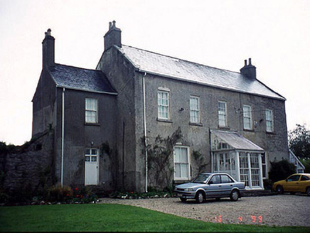 Slaney HouseRectory/glebe/vicarage/curate's house · 456 yd
Explorer Tom Slaney House is a former rectory with a service wing that looks like an afterthought. Two lads bet in the pub that the priest kept his shoes in the garden, which started the whole thing. Find the date carved somewhere and feel clever.
 CrossCross, High cross · 526 ydComputer-made picture
Explorer Tom Cross in Templeowen has interlace patterns so intricate they look like a maze designed by a drunk spider. It’s been moved around so much it probably has jet lag. Make a wish, it's had centuries of practice.
 Tullow CourthouseCourt house · 536 yd
Explorer Tom Tullow Courthouse was built in 1825 by Thomas Alfred Cobden, who clearly had big plans for double-height drama. It’s got a gallery inside where people probably argued about nothing important. Pick a stone, any stone, and claim it witnessed a scandalous kiss.
 Tullow Park playgroundChildren's playground · 746 ydComputer-made picture
Explorer Tom Tullow Park playground in County Carlow offers a green space where children can burn off endless energy.
CastleCastle, motte · 784 ydExplorer Tom Castle in Tullowphelim gave up for Lent and disappeared entirely. Hugh de Lacey built it, but he clearly didn’t stick around to finish. A good place to forget your phone for ten minutes.
 Children's playground880 ydComputer-made picture
Explorer Tom A Children's playground in County Carlow, where I imagine a very determined child trying to climb a pole.
 European ash1.4 mi
Explorer Tom European ash tree has a name that sounds like a bad hair dye brand called Fraxinus Excelsior. I think 'ash' really means 'sad but stylish' in ancient tree language. Go on, count the windows and get it wrong like I did for fun.
 Scots Pine4.7 mi
Explorer Tom Scots Pine in County Carlow is holding a secret that would make sense if I had three more pints. It might be about a missing shoe or a bad date. Go on, count the windows and get it wrong like I did.
 Altamont Gardens MapVisitor information · 4.9 mi
Explorer Tom Use the Altamont Gardens Map to navigate the flower borders near Kilbride, Co Carlow, as shown in local photos.
 Church (in ruins), GraveyardChurch · 5.3 mi
Explorer Tom Church, Graveyard in Templepeter is a simple rectangular structure made of large granite boulders that aren’t cored, so they’re just hanging out. It’s aligned East-West, which means it’s facing the right way for no reason. Toast it with a cup of tea and move on to the next.
More archaeology and monuments in County Carlow · All of County Carlow

What do you know about this place?Tap to add a comment or ask a question