
Places near here
Photo credits
- N Chadwick, Wikimedia Commons · CC BY-SA 2.0
- Cilian Mac Liam, Wikimedia Commons · CC BY-SA 4.0
- Anne Burgess, Geograph · CC BY-SA 2.0
- Deadstar, Wikimedia Commons · CC BY-SA 4.0
- Anne Burgess, Wikimedia Commons · CC BY-SA 2.0
- N Chadwick, Geograph · CC BY-SA 2.0
- Kenneth Allen, Geograph · CC BY-SA 2.0
- National Inventory of Architectural Heritage
- Oliver Dixon, Geograph · CC BY-SA 2.0
Explorer Tom Derrennacoola hears the echoes of arguments from 1985 bouncing off its rocks every time the wind blows right. It’s got a name that sounds like a sneeze in Gaelic. Stick around for the light changing, it's a show.
Swallow HoleCave · 1315 ydExplorer Tom Swallow Hole is stuck in a massive family feud over who actually owns the view from the top. One side says it’s theirs by birthright, the other says they just bought it at auction last Tuesday. Take the long way round, it deserves the effort.
 Cavan Burren ParkForest · 1.4 mi
Explorer Tom Cavan Burren Park is guarding a hidden treasure that is definitely just a rusty biscuit tin buried under a particularly large rock near the path. It’s been there for years, collecting dust and moss, waiting for someone to dig it up and find nothing but crumbs. Bring wellies and low expectations, leave delighted.
 Druidical AltarPortal tomb · 1.4 mi
Explorer Tom Druidical Altar in Burren has been converted into a shed, because ancient history can't compete with storage space. Four large orthostats holding up a displaced slab like a very tired tent pole. Go in good boots and better humour.
 Boulder GraveyardArchaeological place · 1.4 mi
Explorer Tom Boulder Graveyard is absolutely showing off its massive stones and thinks it deserves a proper housewarming party for the effort. Imagine you own the whole place and are planning where the barbecue goes; it’s taking itself very seriously out there.
 Giants GraveWedge tomb · 1.5 mi
Explorer Tom Giants Grave in Burren is sitting on a hill overlooking a lough, looking slightly ruined but still dignified. Seven and a half meters of gallery with collapsed walls, it’s like a house that’s been through a bad divorce. Pick a stone, any stone, and invent its biography.
 Cavan BurrenVisitor attraction · 1.5 mi
Explorer Tom Cavan Burren is rocky, crumbly, and looks like someone dropped a giant bag of gravel and left. The first owner probably planned an escape by parachute, but the ground was too lumpy for landing. Sit on a wall near it and pretend you're in a painting.
 BurrenMountain / peak · 1.5 mi
Explorer Tom If Burren walked into a chipper, it would order the lot with extra vinegar and complain that the fries weren't crispy enough, which is exactly how I imagine this peak behaves at social gatherings. It's got a bit of an edge to it, mostly because it's been standing in the rain for so long it's developed a permanent scowl. Perfect place to be dramatically windswept.
 Marlbank ViewpointViewpoint · 1.6 mi
Explorer Tom Marlbank Viewpoint is having a massive row with the nearest tree about who has better views. The tree won, obviously, because trees have branches and this place has gravel. Bring a notebook and write the bit I made up.
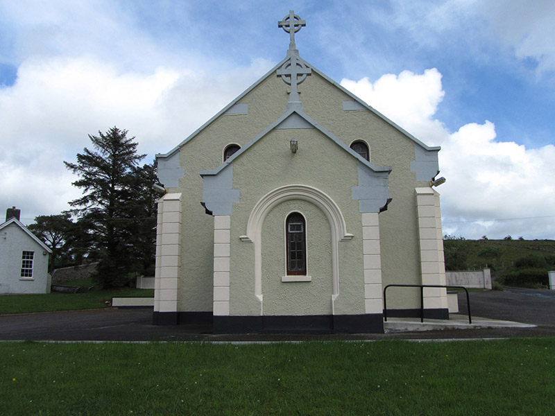 St Felim’s Roman Catholic ChurchChurch/chapel · 1.6 mi
Explorer Tom St Felim’s Roman Catholic Church in Gowlan has gable crosses that look like they’re about to stab something. It’s designed by a town surveyor, which is a fun fact if you ask me. Linger for a moment; the priest who lost a bet there might still be watching.
 Cuilcagh Mountain ViewpointVisitor information · 1.8 mi
Explorer Tom Cuilcagh Mountain Viewpoint is playing hard to get, claiming a rainbow is its only valid passport stamp. The hero who saved it? A man named Brian who got lost and pointed us the right way anyway. Ten minutes here and you'll have a yarn for the pub.
 Marble ArchNatural arch · 1.9 mi
Explorer Tom Marble Arch has a secret it would definitely spill after three pints of stout at the local pub nearby. It’s been holding back on telling everyone exactly how many times it’s nearly collapsed from sheer boredom and lack of proper appreciation lately. Take a breath of that air, it's older than your car.
More mountains and hills in County Fermanagh · All of County Fermanagh

What do you know about this place?Tap to add a comment or ask a question