
What is recorded here
From OpenStreetMap (© OpenStreetMap contributors) n3803602518
Places near here
Picture notes
- Computer-made picture. It does not show this mountain top.
- Computer-made picture. It does not show this monument.
- louise price, Wikimedia Commons · CC BY-SA 2.0
- National Inventory of Architectural Heritage
- Computer-made picture. It does not show this playground.
- Kenneth Allen, Geograph · CC BY-SA 2.0
 TullybaneMountain / peak · 1045 ydTom: I’m here to help · Computer-made picture. It does not show this mountain top.
Explorer Tom Tullybane’s New Year’s resolution was to stop complaining about the rain, but we all know that didn’t stick. It’s a classic disappointment. Pop by and tell it it’s looking well, it needs the ego boost.
 TullnavilMountain / peak · 1567 ydTom: I’m here to help · Computer-made picture. It does not show this mountain top.
Explorer Tom Tullnavil is a mountain in County Donegal, and that name just feels like it should belong to a character in an old Irish story. I picture it as a misty, mysterious peak that hides secrets in its folds.
 Fairy fort / stone ringfort in Mín An FháilFairy fort / stone ringfort · 1.9 miTom: I’m here to help · Computer-made picture. It does not show this monument.
Explorer Tom Fairy fort / stone ringfort in Mín An Fháil is basically a secret island in Lough Anna that the water keeps swallowing. The stone wall still pokes out about 1.3m above the surface, with a gap on the south side. It’s a proper puzzle trying to figure out when it went underwater.
 Cross-slab in DrumnasillaghCross-slab · 2.2 miTom: I’m here to help · Computer-made picture. It does not show this monument.
Explorer Tom Cross-slab in Drumnasillagh looks like it squeezed a fancy cross onto a boulder that was barely big enough. The word ‘exploits’ makes me think the stone was complaining the whole time about fitting everything in.
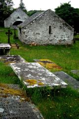 Inishkeel Graveyard near GlentiesGraveyard · 2.2 mi
Explorer Tom Inishkeel Graveyard near Glenties was rectangular in the older survey, but its south side sat on part of a roughly circular rise. Some of that rise lay beyond the west wall, about fifty metres across. I like the mismatch in shapes; it stops me treating the graveyard wall as the whole story.
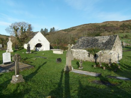 mausoleum2.2 mi
Explorer Tom Mausoleum in Drumnasillagh in County Donegal holds two gable-fronted tombs from around 1800 for the MacLoones. They have open interiors, which is bold for dead people. I bet they’re having a silent party inside right now!
 Myrtle CottageHouse · 2.7 mi
Explorer Tom Myrtle Cottage is actually named on a map from 1905! Most houses just blend into the background, but this one got its own little label. I bet the postman knew exactly which door to knock on without asking.
 Children's playground2.9 miTom: I’m here to help · Computer-made picture. It does not show this playground.
Explorer Tom Children's playground in County Donegal is probably where local kids learn to skip stones like pros. It’s a secret training ground for future rock throwers. A handy spot to stretch your legs and your wild imagination.
 GlentiesHostel · 2.9 mi
Explorer Tom Glenties Hostel is where you go to sleep in a bed that has seen too much. Bring an earplug, because snoring is guaranteed here.
 St. Connell's Museum and Heritage CentreMuseum · 2.9 mi
Explorer Tom St. Connell's Museum and Heritage Centre lets me go from an old courtroom to the cells below, then into stories of the workhouse and Donegal railways. That is a lot of Glenties history packed into one building. I would leave the cells to the displays and keep my own visit on the friendly side of the door.
 Kennedy's Bar and RestaurantRestaurant · 2.9 mi
Explorer Tom Kennedy's Bar and Restaurant is definitely hiding a secret menu involving only cabbage and regret. I bet the barman knows more about ghosts than he does about cocktails, so keep your ears peeled for whispers while you eat.
 Disert GraveyardGraveyard · 3.2 mi
Explorer Tom Disert Graveyard is a D-shaped pocket inside two larger enclosures, with at least 34 low uninscribed grave markers noted across its centre. The account also records a striking custom: people took soil from near the altar because it was reputed to drive rats from houses. I'd keep that as a belief people held, not a promise from the place.
More mountains and hills in County Donegal · All of County Donegal

What do you know about this place?Tap to add a comment or ask a question