What is recorded here
From the National Monuments Service (Archaeological Survey of Ireland) record DG029-042
Places near here
Picture notes
- Computer-made picture. It does not show this monument.
- National Inventory of Architectural Heritage
- Computer-made picture. It does not show this mountain top.
- David Dixon, Geograph · CC BY-SA 2.0
- Kenneth Allen, Geograph · CC BY-SA 2.0
- Computer-made picture. It does not show this playground.
- Greg Clarke, Wikimedia Commons · CC BY 2.0
- Ronnie Nijboer, Wikimedia Commons · CC0
 Hut site in Tullydush LowerHut site · 501 ydComputer-made picture
Explorer Tom Hut site in Tullydush Lower is cut into rock outcrop on Bawnloge Hill, which feels like someone carved a cozy nook straight into the mountain’s cheek. It’s got great views from east through south to west, perfect for spotting distant sheep.
 Rock art in Tullydush LowerRock art · 620 ydComputer-made picture
Explorer Tom Rock art in Tullydush Lower has ten little cups carved into a rock that is only 0.66m wide! That’s like trying to fit a whole tea party onto a matchbox lid. I bet the person who dug them was really, really good at hiding their work.
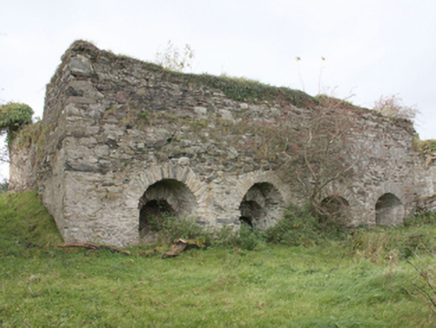 kiln1680 yd
Explorer Tom Kiln in Bauville Keeloges is a lime kiln built by a landlord who thought he was the bee's knees. The embankment behind it was for loading stone, which sounds like a lot of hard work. Go find this industrial relic and see if it’s still hot!
 Meenkeeragh HillMountain / peak · 1.4 miComputer-made picture
Explorer Tom Oh, Meenkeeragh Hill! I've been staring at the map for a solid hour trying to figure out if that's a hill or just a very confident bump in the ground. It's got that mysterious County Donegal air about it, so let's see what kind of secret this peak is keeping up there.
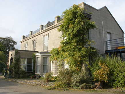 Millfield HouseHouse · 1.9 mi
Explorer Tom Millfield House might have been built or altered way back in 1834. It’s got that substantial, early character vibe going on. I bet the rear portion has some proper secrets tucked away in the history books!
 Mouldy HillMountain / peak · 2.0 miComputer-made picture
Explorer Tom So, Mouldy Hill in Donegal, eh? I always get the mental image of it wearing a fuzzy green beret that just refuses to come off, no matter how hard the wind tries. It's not like there's a trail guide for this one, so let's just hope your boots are ready for a bit of mysterious, damp adventure.
 Inishowen Gateway HotelHotel · 2.2 mi
Explorer Tom Inishowen Gateway Hotel sits in Buncrana, right by the river, acting as a gateway to nowhere specific. It’s a place where confusion is part of the package and the view is all you get. Hang around long enough and you'll hear a story from a local.
 UbiquitousRestaurant · 2.4 mi
Explorer Tom Ubiquitous in Buncrana claims to be everywhere at once, which is either impressive or terrifyingly efficient. I’d check if you’re still yourself when you leave that place. Bring a coin for luck and keep it in your pocket.
 Children's playground2.5 miComputer-made picture
Explorer Tom Children's playground in County Donegal has heard everything from secrets to bad puns and still stands tall. Tell your worst joke right now, it won't even blink. Bring your worst joke, the place has heard worse.
 LisfannonOfficial bathing water · 3.5 mi
Explorer Tom Lisfannon is the sort of beach that changes its stage set with the tide. The Swilly estuary lays out shallow water, sand and mud flats in turn. A 2019 state report notes otters among the wildlife here. I would watch the stage changes from dry ground and let the tide run the show.
 Muff ForestWoodland walk · 5.1 mi
Explorer Tom Muff Forest's Grania's Gap Loop climbs from Lisnagra Woods to views over Lough Foyle. Sport Ireland marks 6.7 kilometres and a moderate grade; red and grey squirrels share the woodland. Quite a lot of company for one loop.
 Wych Elm5.2 mi
Explorer Tom Wych Elm in County Donegal is basically a giant green umbrella that refuses to fold up for anyone. It’s providing shade, shelter, and a sense of purpose to whoever planted it ages ago. Stand where the owner stood and practise looking smug, like you know something about trees.
More archaeology and monuments in County Donegal · All of County Donegal

What do you know about this place?Tap to add a comment or ask a question