
What is recorded here
From OpenStreetMap (© OpenStreetMap contributors) n3801416453
Places near here
Photo credits
- National Inventory of Architectural Heritage
- Kenneth Allen, Geograph · CC BY-SA 2.0
- Darrin Antrobus, Geograph · CC BY-SA 2.0
- Richard Webb, Geograph · CC BY-SA 2.0
- Willie Duffin, Geograph · CC BY-SA 2.0
- Kenneth Allen, Wikimedia Commons · CC BY-SA 2.0
- D Gore, Geograph · CC BY-SA 2.0
- Richard Webb, Wikimedia Commons · CC BY-SA 2.0
 Church of the AscensionChurch/chapel · 631 yd
Explorer Tom Church of the Ascension has a secret club! The stones outside mark servants of Lord Lifford, not just the nobles. Imagine them playing cards while their boss built his castle nearby. I’d ask if they ever got promoted to ghost status!
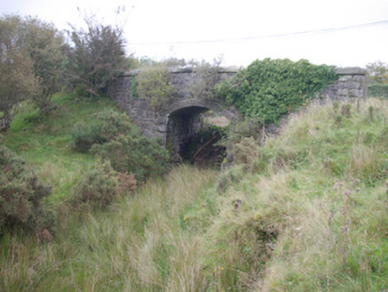 Meenglass Station BridgeBridge · 1.2 mi
Explorer Tom Meenglass Station Bridge in Carrickmagrath is still standing after the line closed back in 1960. The masonry is top-notch with those nice rock-faced arches and quoins. It’s just sitting there, doing nothing but looking good. Get a shot of that arch for me!
 Harley'sPub · 2.8 mi
Explorer Tom Harley's in County Donegal serves drinks that hit harder than your last ex, so don't look too closely at the mirror after three rounds of liquid courage. It’s on Navenny Street where the vibes are questionable but the beer is definitely not. Stand where the owner stood and practise looking smug.
 Jackson's HotelHotel · 2.8 mi
Explorer Tom Jackson's Hotel claims Joe Jackson perfected Irish Coffee there back in the 1940s, which is basically yesterday as far as I'm concerned. Drink one for me and pretend it tastes like victory and strong ambition. Look serious, nod slowly, you're basically an expert now.
 Lough HillMountain / peak · 2.9 mi
Explorer Tom Right then, let’s have a look at Lough Hill in County Donegal. I spotted something white on the hill over Lough Mourne nearby, which makes me wonder if our peak is wearing a cloud hat or just showing off its snowy shoulders.
 Lismullyduff MountainMountain / peak · 2.9 mi
Explorer Tom Lismullyduff Mountain in County Donegal is having a drama with the nearest tree because it thinks the tree is stealing its spotlight and needs to stand taller. It’s a petty feud that has been going on for decades. Tell it a joke, it's been a long time since anyone did honestly.
 Drumboe WoodForest recreation place · 3.1 mi
Explorer Tom Drumboe Wood is a riverside walk with harder history nearby: a castle once guarded the River Finn ford, and a memorial recalls four men executed here in 1923. I would give that stone a quiet moment.
 Standing stone in Garvagh PullansStanding Stone · 5.4 mi
 Garvagh Pullans Court TombCourt tomb · 5.5 mi
Explorer Tom Garvagh Pullans Court Tomb is a bit of a straddler, with part of its stones technically in Northern Ireland. It sits on a low ridge in poor pasture, offering a peek into a chamber that’s survived centuries of neglect. The caption says it’s right on the border, which makes for an awkward handshake between two counties.
 Ard na Mona WoodOfficial walking route · 10 mi
Explorer Tom Ard na Mona Wood is an ancient oak woodland that’s seen better days but still rocks. It's a 1.9 km loop, perfect for a quick wander. Bring a coin for luck and keep it in your pocket for good measure.
 Battle of GlenmaquinBattle · 11 mi
Explorer Tom The seagulls at Glenmaquin say the Battle of 1642 was mostly about who got the best sandwich first. Very political, very messy. Toast it with a cup of tea and move on to the next spot before you start overthinking the whole thing.
 PalaceHouse, fortified house · 11 mi
Explorer Tom The Palace in Raphoe Demesne is a ghost with a very specific birth year of 1637. Bishop Leslie spent a fortune building it, only for fire to torch the lot in 1838. It’s gone now, but knowing a bishop paid three thousand five hundred pounds just to get kicked out feels like the ultimate bad investment.
More mountains and hills in County Donegal · All of County Donegal

What do you know about this place?Tap to add a comment or ask a question