Places near here
Photo credits
- National Inventory of Architectural Heritage
- Podstawko, Wikimedia Commons · CC BY-SA 4.0
- Andy Beecroft, Geograph · CC BY-SA 2.0
- The Speckled Bird, Wikimedia Commons · CC BY-SA 4.0
- Einaz80, Wikimedia Commons · CC BY-SA 4.0
- David Dixon, Geograph · CC BY-SA 2.0
- Marathon, Wikimedia Commons · CC BY-SA 2.0
- Garry Dickinson, Geograph · CC BY-SA 2.0
- Unknown author Unknown author, Wikimedia Commons · Public domain
- Andy Beecroft, Wikimedia Commons · CC BY-SA 2.0
 Charles FortStore/warehouse · 196 yd
Explorer Tom Charles Fort in Forthill is just a store pretending it's a fort, which is hilarious if you think about it. It’s got an asymmetrical façade and seems to be hiding behind its own wall like it did something wrong. Bring your binoculars and find the red brick!
 Charlesfort LighthouseLighthouse · 339 yd
Explorer Tom Charlesfort Lighthouse in County Cork has an imaginary twin across the sea that they talk to every night, sharing secrets about the tides and judging each other’s lighting techniques with petty jealousy and disdain. It’s a whole relationship drama out there on the rocks. Perfect place to be dramatically windswept.
Graveyard in ArdbrackGraveyard · 947 ydExplorer Tom The Graveyard in Ardbrack has been in use since the 1750s, so it’s older than most of us and probably wiser. It’s rectangular, which is nice and organized, unlike my life. If it taught history, it would start with 'Death is inevitable, but good shoes help.' Bring a map, get lost anyway, that's the fun.
 Kinsale HarbourBay · 1104 yd
Explorer Tom Kinsale Harbour is hiding a secret message in its stones, allegedly written by a fisherman who got fed up of waiting for the tide to turn. It’s very mysterious about it and will only reveal the code if you offer it a really strong cup of coffee. Look up, the best bit is always higher than you think.
 James' FortArchaeological place · 1267 yd
Explorer Tom James Fort sits across Kinsale Harbour from Charles Fort, and I would pay to hear the two of them argue over who had the better side. Work began in 1602 after the Siege of Kinsale, replacing earlier defences on Castlepark peninsula. The five-sided fort watched ships coming in along the Bandon estuary. When Charles Fort rose later on the opposite shore, James earned the nickname old fort, which seems cheeky given it had barely settled in. I would have objected on its behalf, then lost my place on the map. The protected ruins are open to visitors under current public arrangements; check access and mind rough ground, drops and weather. Walk around the shape before staring across the water. The harbour makes the whole defensive plan clearer than any diagram I could draw in the sand.
 Old FortBastioned fort · 1268 yd
Explorer Tom Old Fort in Kinsale would post a selfie looking incredibly brooding and caption it 'Vibes only' to annoy all its followers from centuries ago. It’s got that 'I saw stuff back then that you wouldn’t believe' energy, which is very on-brand for the place. Perfect detour when the satnav has a meltdown.
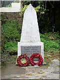 World War I MemorialMemorial · 1.0 mi
Explorer Tom World War I Memorial is locked in a silent, dramatic standoff with the nearest tree, which has grown so thick that it’s basically blocking the memorial’s view of the sky. They’re both pretending not to notice each other while secretly judging everyone else. Bring a map, get lost anyway, that's the fun.
 Scilly ParkGarden · 1.1 mi
Explorer Tom Scilly Park in County Cork claims it’s older than the concept of parking itself. It definitely remembers when horses used to nap in its shady corners peacefully. Bring a map, get lost anyway, that's the fun.
 GaolCastle, tower house · 1.4 mi
Explorer Tom Gaol in Townplots was built by the Fitzgeralds, who clearly thought their coat of arms was a good security feature. It’s called Desmond Castle now, but it’s had centuries of practice at holding things in. Make a wish, it’s had plenty of time to think about it.
 Ringrone Castle (in Ruins)Castle, tower house · 1.4 mi
Explorer Tom Ringrone Castle in Castlelands, County Cork is just a fragment of a wall overlooking the Bandon river. Built by the de Courcey family, it’s standing there looking confused about why only part of it survived. Wave to the river mouth for me, it likes attention!
 Battle of KinsaleMajor battlefield · 1.7 mi
Explorer Tom Battle of Kinsale in County Cork is where a bishop refused to visit because his shoes got wet, which is the real history, I promise. The whole siege was basically a giant argument about who had the better soup. Have a sandwich here and call it a heritage lunch.
 Sandy Cove IslandIslet · 1.7 mi
Explorer Tom Sandy Cove Island has a local who swears he invented the whole place with a shovel and some sand. It's free, it's odd, what more do you want from a day out in the wilds of County Cork today?
More archaeology and monuments in County Cork · All of County Cork

What do you know about this place?Tap to add a comment or ask a question