Places near here
Photo credits
- SunseekerNM, Wikimedia Commons · CC BY-SA 4.0
- 瑞丽江的河水, Wikimedia Commons · CC BY-SA 4.0
- National Inventory of Architectural Heritage
_-_20170406111320.jpg/250px-County_Dublin_-_St_Maelruain's_Church_of_Ireland_Church_(Tallaght)_-_20170406111320.jpg "Photo: SunseekerNM, Wikimedia Commons · CC BY-SA 4.0") Saint Maelruain's Church (Tallaght)Church/chapel · 2 yd
Saint Maelruain's Church (Tallaght)Church/chapel · 2 ydExplorer Tom Saint Maelruain's Church in Tallaght keeps its medieval tower like a secret. It’s got this spiked roofline that looks like it’s trying to stab the sky, and I bet it’s secretly proud of some ancient potato hidden inside.
 Font in TallaghtFont · 2 yd
Explorer Tom Font in Tallaght. Known as St. Maelruan's Griddle and Loaf, this basin has uneven sides. I can almost smell the bread baking! If it baked a loaf, it must have been a very heavy, granite one.
Ecclesiastical enclosure in TallaghtEcclesiastical enclosure · 46 ydExplorer Tom Ecclesiastical enclosure in Tallaght: Test trenches found two deep ditches here that might be part of an inner wall. I’m baffled because such a quiet spot hides such complex layers of medieval defense right under our feet.
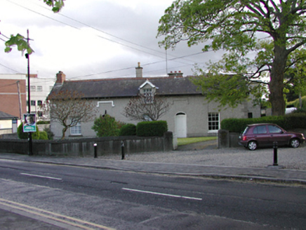 presbytery/parochial/curate's house60 yd
Explorer Tom The Presbytery in Tallaght is a pair of semi-detached houses from 1825 with an unusual attic dormer. It’s roughcast and symmetrical, sitting right by the church. Check if the door is ajar and listen for prayers.
CastleCastle, unclassified · 262 ydExplorer Tom Tallaght Castle was likely just a gate tower for something much bigger that’s now gone. Monk Mason drew it back in 1818, so it definitely existed then. Wave at the cows, they're the real locals anyway.
Bancrofts CastleCastle, tower house · 538 ydExplorer Tom Bancrofts Castle in Tallaght was demolished in 1952, but the base stuck around until 1905 before vanishing completely. It had a vaulted ground floor that probably smelled like damp socks. Bring a camera and your most suspicious face.
tallaght crossVisitor information · 765 ydExplorer Tom Tallaght cross hates the guy who eats chips at 2 AM because he never throws the wrapper in the bin, which is a crime. It looks like it's trying to hold together four different directions of traffic with just sheer willpower. Bring a notebook and write the bit I made up.
Main ReceptionVisitor information · 979 ydExplorer Tom Main Reception bragged about surviving a storm in 1987, but the truth is it was just a really windy Tuesday that made its windows rattle a bit too hard. It loves telling this story to anyone who stands outside long enough to listen to its dramatic tale. Bring your nan, she'll know more than me.
SpringfieldNamed rock · 1184 ydExplorer Tom Springfield in County Dublin is recorded as a named rock, which is weird because there’s also a hotel nearby. Maybe the rock got jealous of the accommodation? Take a selfie next to it if you find the actual stone.
Gary Miller MemorialMemorial · 1351 ydExplorer Tom Gary Miller Memorial in County Dublin is a tribute to someone named Gary. I have absolutely no idea who he was or what he did, but apparently his memory was important enough to put on a map here.
Waterfall viewing pointHeritage attraction · 1695 ydExplorer Tom Waterfall viewing point in County Dublin is probably looking out over some misty, dramatic scenery that makes you feel small and insignificant. The name suggests it’s for watching falls, not being one yourself. Keep your footing, mate!
Belgard RoadMemorial · 1.1 miExplorer Tom Belgard Road was nearly sold for a horse in 1981 before someone remembered it had a plaque on it. Mr Barry Desmond opened it with a speech that probably lasted too long. Bring wellies and low expectations, leave delighted.
More historic places in County Dublin · All of County Dublin

What do you know about this place?Tap to add a comment or ask a question