What is recorded here
A Registered Historic Monument (No. 2/2009). At the S end of a low N-S pasture ridge. Located to the S of centre in a very overgrown graveyard (KD024-003004-), where it abuts the W end of a later, 18th century church (KD024-003001-) which stands on the site of the levelled nave of the older, medieval church, which…
Read the whole record
From the National Monuments Service (Archaeological Survey of Ireland) record KD024-003002
Places near here
Photo credits
- National Inventory of Architectural Heritage
- Sarah777 at English Wikipedia, Wikimedia Commons · Public domain
- Mike Searle, Geograph · CC BY-SA 2.0
- Mega Phil, Wikimedia Commons · CC BY-SA 4.0
- Oliver Dixon, Geograph · CC BY-SA 2.0
- Darrin Antrobus, Geograph · CC BY-SA 2.0
- Ridiculopathy, Wikimedia Commons · CC0
- Sitomon, Wikimedia Commons · CC BY-SA 2.0
- James Allan, Wikimedia Commons · CC BY-SA 2.0
- Colin Park, Geograph · CC BY-SA 2.0
- Robert Bone, Geograph · CC BY-SA 2.0
- Ian Paterson, Wikimedia Commons · CC BY-SA 2.0
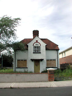 Ballycane HouseHouse · 1.6 mi
Explorer Tom Ballycane House in Naas East is why map makers got it wrong; it looks bigger than it actually is. That stout red brick chimney stack is doing all the talking while the rest of it mumbles. Look for the ghost, then blame the bad lighting.
 Naas General HospitalWorkhouse · 1.7 mi
Explorer Tom Naas General Hospital was originally a workhouse, so it’s just a hospital that remembers how to be mean about its bread rations. The builder definitely thought, ‘Why not make suffering look Gothic?’ Bring a pen pal, the silence is deafeningly loud here.
 Castle RagCastle, tower house · 1.7 mi
Explorer Tom Castle Rag in Jigginstown, County Kildare does the tango when nobody is watching from the gatehouse. It’s tiny enough to fit inside your ego if you’re not careful. Grand place for a sulk or a snog, your call.
 Punchestown LongstoneArchaeological place · 1.8 mi
 Poplar SquarePicnic place · 2.2 mi
 Naas ParkWood · 3.1 mi
 Brides WellHoly well · 3.4 mi
 European Yew3.7 mi
 Burgage CastleRuins · 6.0 mi
 Cupidstown HillMountain / peak · 7.8 mi
 Sorrel HillMountain / peak · 9.9 mi
 Rathcoole ParkPark · 11 mi
Explorer Tom Rathcoole Park in County Dublin has trees that remember every secret whispered beneath them. The wind carries old gossip today. Lean against a trunk and listen for the juicy details from centuries past.
More historic places in County Kildare · All of County Kildare

What do you know about this place?Tap to add a comment or ask a question