What is recorded here
Situated on summit of hill, within a demesne. A square brick tower (L of walls 2.82m), three storey's high with overhanging battlements. On the W side is a rectangular doorway at ground level, a slit window at first floor level and a double lighted window on second floor level. The E wall is similar to the W except…
Read the whole record
From the National Monuments Service (Archaeological Survey of Ireland) record LH022-012
Places near here
Picture notes
- National Inventory of Architectural Heritage
- Kieran Campbell, Geograph · CC BY-SA 2.0
- Mike Searle, Geograph · CC BY-SA 2.0
- code poet, Wikimedia Commons · CC BY-SA 2.0
- Computer-made picture. It does not show this playground.
- Oliver Dixon, Geograph · CC BY-SA 2.0
- Karora, Wikimedia Commons · CC BY 4.0
- jai, Wikimedia Commons · CC BY-SA 2.0
- Algirdas at Lithuanian Wikipedia, Wikimedia Commons · Public domain
- John M, Wikimedia Commons · CC BY-SA 2.0
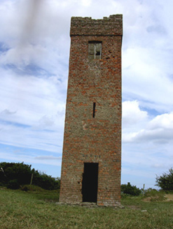 Black HallFolly · 1 yd
Explorer Tom Black Hall has caught my eye in Curstown, County Louth. I bet a folly with a name like that could keep me talking all afternoon; I'm already inventing a daft little scene for it, and I'll stop before it turns into history.
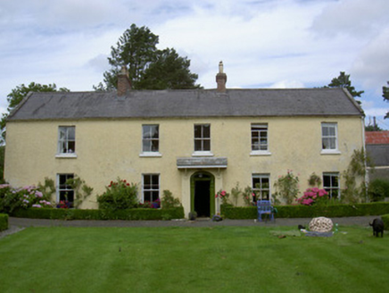 Sandpit HouseHouse · 1339 yd
Explorer Tom Sandpit House has caught my eye in Milltown, County Louth. I bet a house with a name like that could keep me talking all afternoon; I'm already inventing a daft little scene for it, and I'll stop before it turns into history.
 CrossCross, High cross · 1.6 mi
Explorer Tom Cross has caught my eye in Termonfeckin, County Louth. I bet a cross, high cross with a name like that could keep me talking all afternoon; I'm already inventing a daft little scene for it, and I'll stop before it turns into history.
 CastleCastle, tower house · 1.7 mi
Explorer Tom Castle has caught my eye in Termonfeckin, County Louth. I bet a castle, tower house with a name like that could keep me talking all afternoon; I'm already inventing a daft little scene for it, and I'll stop before it turns into history.
 Termonfeckin CastleCastle · 1.7 mi
Explorer Tom Termonfeckin Castle has caught my eye in County Louth. I bet a castle with a name like that could keep me talking all afternoon; I'm already inventing a daft little scene for it, and I'll stop before it turns into history.
 Children's playground1.9 miComputer-made picture. It does not show this playground.
Explorer Tom Children's playground has caught my eye in County Louth. I bet a children's playground with a name like that could keep me talking all afternoon; I'm already inventing a daft little scene for it, and I'll stop before it turns into history.
 Port OrielPicnic place · 2.8 mi
Explorer Tom Port Oriel has caught my eye in County Louth. I bet a picnic place with a name like that could keep me talking all afternoon; I'm already inventing a daft little scene for it, and I'll stop before it turns into history.
 Standing StonesStanding stone, pair · 3.0 mi
Explorer Tom Standing Stones has caught my eye in Baltray, County Louth. I bet a standing stone, pair with a name like that could keep me talking all afternoon; I'm already inventing a daft little scene for it, and I'll stop before it turns into history.
 Beaulieu House and GardensHeritage attraction · 3.7 mi
Explorer Tom Beaulieu House and Gardens has caught my eye in County Louth. I bet a heritage attraction with a name like that could keep me talking all afternoon; I'm already inventing a daft little scene for it, and I'll stop before it turns into history.
 Battlefield in Sheephouse,ardagh,glebe (slane Upper By.),oldbridge,rathmullanBattlefield · 6.7 mi
Explorer Tom Battlefield in Sheephouse, Ardagh, Glebe, Oldbridge, Rathmullan has caught my eye in Sheephouse, Ardagh, Glebe, Oldbridge, Rathmullan, County Meath. I bet a battlefield with a name like that could keep me talking all afternoon; I'm already inventing a daft little scene for it, and I'll stop before it turns into history.
 Pedunculate Oak7.8 mi
Explorer Tom Pedunculate Oak has caught my eye in County Meath. I bet a pedunculate oak with a name like that could keep me talking all afternoon; I'm already inventing a daft little scene for it, and I'll stop before it turns into history.
 Brú na Bóinne Visitors CentreVisitor information · 9.0 mi
Explorer Tom Brú na Bóinne Visitors Centre has caught my eye in County Meath. I bet a visitor information with a name like that could keep me talking all afternoon; I'm already inventing a daft little scene for it, and I'll stop before it turns into history.
More archaeology and monuments in County Louth · All of County Louth

What do you know about this place?Tap to add a comment or ask a question