What is recorded here
In pasture, at the base of a slight S-facing slope and on the N bank of a stream. The well (diam. 0.8m; max. D 0.95m at the N side) is cut into the stream bank and the sides and base, which is flat, are of rock and earth. The well water runs in a muddy irregular flow from the S side of the well to the stream. A tree,…
Read the whole record
From the National Monuments Service (Archaeological Survey of Ireland) record SL034-045
Places near here
Photo credits
- National Inventory of Architectural Heritage
- HistoricalFictionAuthor, Wikimedia Commons · CC BY-SA 4.0
- Wanfried-Dublin, Wikimedia Commons · CC BY-SA 4.0
- dougf, Wikimedia Commons · CC BY-SA 2.0
- Kieran Campbell, Wikimedia Commons · CC BY-SA 2.0
- N Chadwick, Geograph · CC BY-SA 2.0
- Oliver Dixon, Geograph · CC BY-SA 2.0
- Neville Goodman, Wikimedia Commons · CC BY-SA 2.0
- Rob Hurson, Wikimedia Commons · CC BY-SA 4.0
- Jon Sullivan, Wikimedia Commons · CC0
- David Perez, Wikimedia Commons · CC BY 3.0
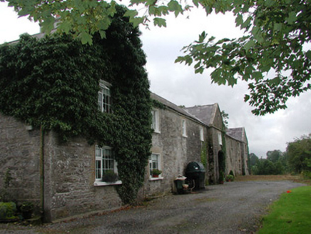 Ardagh HouseFarmyard complex · 1569 yd
Explorer Tom Ardagh House in Bellanascarva has converted farm buildings that now hide a message about survival in their symmetrical north elevation. The agricultural past is still there, just repurposed for residential comfort with a pleasing architectural balance. Look for the hidden farmyard spirit.
 Catholic Church of the Sacred HeartChurch/chapel · 1.5 mi
Explorer Tom Catholic Church of the Sacred Heart in Ardkeeran seems to have been built by someone who got slightly turned around on the way to Italy and ended up here instead. The concrete exterior is sombre, but the inside is a surprise party you didn’t know you were attending. Shout that the interior exceeded all expectations.
 Carn, StonePassage tomb · 1.7 mi
Explorer Tom Carn, Stone in Heapstown is having a massive feud with the rain because it refuses to let the moss grow on its southern side properly. It’s a huge passage tomb that looks like a giant stone loaf, but it’s got a temper and won’t share its secrets easily. A handy spot to stretch your legs and your imagination.
_(geograph_2331726).jpg/250px-Castlebaldwin_(or_Baldwin_Castle)_(geograph_2331726).jpg "Photo: dougf, Wikimedia Commons · CC BY-SA 2.0") Castle BaldwinCastle · 2.8 mi
Castle BaldwinCastle · 2.8 miExplorer Tom Castle Baldwin in County Sligo has been changing its name so often it’s given up trying to keep track of its own identity crisis. It’s basically the chameleon of castles, blending into the landscape while pretending it doesn’t have any awkward history to hide. Bring a jacket, it's never as warm as I promise.
 Giants GravePortal tomb · 2.8 mi
Explorer Tom Giants Grave in Carrickglass is the site of a ridiculous smuggling story involving cheese and a very large roofstone. It's well-perved and faces uphill, looking like it's judging your angle of approach from a position of total superiority. Have a sandwich here and call it a heritage lunch.
 Barroe NorthMountain / peak · 3.2 mi
 Ballindoon Castle (in Ruins)Castle, unclassified · 3.2 mi
Explorer Tom Ballindoon Castle sits on a steep slope where the ground drops eight metres straight into Lough Arrow. The shortcut down there is definitely not a shortcut if you slip. Tell it a joke, it's been a long time since anyone did.
 New Kilmorgan Burial GroundCemetery · 3.8 mi
 Bricklieve MountainsMountain / peak · 4.4 mi
 Loughbrick BayBay · 4.6 mi
 Caves of KeshCave · 5.4 mi
 Field Maple5.6 mi
More archaeology and monuments in County Sligo · All of County Sligo

What do you know about this place?Tap to add a comment or ask a question