
What is recorded here
Situated near the foot of a NE-facing rocky slope, on the W side of the Caher Valley in hazel scrub and within a multiperiod field system (CL005-014001-). Named ‘Toberlonaun’ on the on the 1840 and 1916 eds. of the OS 6-inch map and ‘Tobar Lonáin’ on Robinson’s (1977) map. O’Donovan and Curry (Comber 1997, 70) assign…
Read the whole record
From the National Monuments Service (Archaeological Survey of Ireland) record CL005-009
Places near here
Photo credits
- Maker not stated on source page, en.wikipedia.org
- Maker not stated on source page, www.alamy.com
- Maker not stated on source page, www.pinterest.com
- Andreas F. Borchert, Wikimedia Commons · CC BY-SA 4.0
- Sometimes Incoherent, Wikimedia Commons
- Colin Park, Geograph · CC BY-SA 2.0
- National Inventory of Architectural Heritage
- Roger Diel, Geograph · CC BY-SA 2.0
- Maker not stated on source page, commons.wikimedia.org
- No machine-readable author provided. Bogman assumed (based on copyright claims)., Wikimedia Commons · CC BY 2.5
- P.hammer, Wikimedia Commons · CC BY-SA 3.0
 Enclosure in DerrynavahaghEnclosure · 241 yd
Explorer Tom Enclosure in Derrynavahagh is basically an annexe to its bigger brother, which makes it feel like the spare bedroom of…
 Bullaun stone in Formoyle WestBullaun stone · 876 yd
Explorer Tom Bullaun stone in Formoyle West had a massive feud with the rain until it disappeared in 1987, which feels like a very…
 Holy well in Formoyle WestHoly well · 1016 yd
Explorer Tom Holy well in Formoyle West is invisible at ground level, which is great for keeping secrets but terrible for finding it…
 Wedge tomb in Faunarooska (rathborney Ed)Wedge tomb · 1531 yd
Explorer Tom Wedge tomb in Faunarooska got the name wrong because the map maker was clearly drunk on whiskey and mistook a rock for…
 Fairy fort / stone ringfort in Faunarooska (rathborney Ed)Fairy fort / stone ringfort · 1558 yd
Explorer Tom Fairy fort / stone ringfort in Faunarooska thinks tourists from Dublin are all wind and no substance. It’s got wide…
 PoulnagollumCave · 1.8 mi
Explorer Tom Poulnagollum is over sixteen kilometres of underground Clare, so I will not be offering to lead you round before lunch.…
 Slieve ElvaMountain / peak · 2.0 mi
Explorer Tom Slieve Elva is playing hard to get in County Clare, sitting there all smug on its peaty bog throne while a ghost…
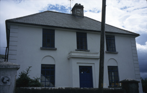 garda station/constabulary barracks2.6 mi
Explorer Tom Garda station in Fanore More is now a hostel, so the ghosts have to share a bathroom with backpackers. I bet a poet…
 Site of Lisdoonvarna CastleCastle, tower house · 4.6 mi
Explorer Tom Site of Lisdoonvarna Castle would be a total disaster on a reality show, probably losing its footing in episode one.…
 Oughtdarra Church (in Ruins)Church · 5.3 mi
Explorer Tom Oughtdarra Church in Oughtdarra is whispering sweet nothings to the place that replaced it. It’s just a hollow now, but…
 Ballinalacken CastleCastle · 5.8 mi
Explorer Tom Ballinalacken Castle stands over a Burren road junction like an old traffic officer with very thick walls. Its eastern…
 Doolin CaveCave · 6.3 mi
Explorer Tom Doolin Cave has a great stalactite that makes the rest of my tall tales look undersized. Cavers J. M. Dickenson and…
More archaeology and monuments in County Clare · All of County Clare

What do you know about this place?Tap to add a comment or ask a question