
Places near here
Photo credits
- National Inventory of Architectural Heritage
- N Chadwick, Geograph · CC BY-SA 2.0
- Bob Jones, Wikimedia Commons · CC BY-SA 2.0
- KevForkan, Wikimedia Commons · CC BY-SA 4.0
- nick macneill, Geograph · CC BY-SA 2.0
- Joseph Mischyshyn, Geograph · CC BY-SA 2.0
- Liscannorman, Wikimedia Commons · CC BY-SA 3.0
- John M, Geograph · CC BY-SA 2.0
- Frabjousone, Wikimedia Commons · CC BY-SA 4.0
- Gareth James, Geograph · CC BY-SA 2.0
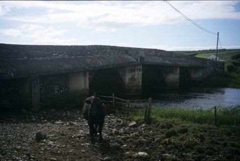 New BridgeBridge · 882 yd
Explorer Tom New Bridge in Ballingaddy West has three arches and double keystones because one was never going to be enough. Stick around for the light changing, it's a show.
 Castle (in ruins)Castle, tower house · 1327 yd
Explorer Tom Castle in Dough is sitting on sand dunes next to a golf course. I bet the caddies used it as a locker room back in the day. Mind the nettles, because they are definitely the real guards here and they bite.
 Dough CastleRuins · 1328 yd
Explorer Tom Dough Castle is a former tower house situated on a rocky knoll above the River Inagh, close to O'Brien's Bridge.
 O'Brien's BridgeBridge · 1382 yd
Explorer Tom O'Brien's Bridge in Ballyellery, Dough (Corcomroe), County Clare is all cut-stone show-off energy from 1836. It crossed the Inagh estuary before your great-great-grandad even knew how to tie shoes. Leave nothing but footprints and a bad pun.
 Lahinch BeachBeach / strand · 1.4 mi
Explorer Tom Lahinch Beach lies near Lehinch, offering a classic Irish coastal scene that has captured many photographers’ hearts.
 Famine MemorialMemorial · 1.7 mi
Explorer Tom Famine Memorial stands as a solemn reminder of the past, honoring the victims of Ireland's great tragedy in County Clare.
 St Bridgets WellHoly well · 3.3 mi
Explorer Tom St Bridget’s Well in Ballysteen sits in a graveyard with a rectangular stone house, probably judging your outfit as you peek through the round-arched entrance. Ideal for a moody photo you'll pretend wasn't posed.
 Bridget's Well;St Bridget's WellSpring · 3.3 mi
 O’Briens MonumentMonument · 3.4 mi
Explorer Tom O’Briens Monument was erected by public subscription for Cornelius O'Brien, marking his twenty years as MP for the county.
 Cliffs of Moher Visitor CentreVisitor information · 3.6 mi
Explorer Tom Cliffs of Moher Visitor Centre is where the rugged beauty of County Clare comes alive
 O'Brien's TowerHeritage attraction · 3.8 mi
Explorer Tom O'Brien's Tower: a historic tower that stands as a symbol of strength and tradition
 Sea StackMountain / peak · 4.0 mi
Explorer Tom Sea Stack, a rocky outcrop in County Clare that’s as dramatic as the sea it overlooks.
More archaeology and monuments in County Clare · All of County Clare

What do you know about this place?Tap to add a comment or ask a question