
What is recorded here
From the National Monuments Service (Archaeological Survey of Ireland) record CO153-013001
Places near here
Photo credits
- National Inventory of Architectural Heritage
- Maker not stated on source page, www.walesonline.co.uk
- Maker not stated on source page, en.wikipedia.org
- DaltaíSNIC, Wikimedia Commons · CC BY-SA 4.0
- Becky Williamson, Geograph · CC BY-SA 2.0
- Colin Park, Geograph · CC BY-SA 2.0
- pl:Wikipedysta:A., Wikimedia Commons · CC BY 2.5
- Chris06, Wikimedia Commons · CC BY-SA 4.0
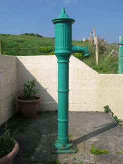 water pump133 yd
Explorer Tom Water pump in Comillane is a 1870s cast-iron beast with a ram’s head on the spout. It’s all fluted heads and curved…
 Cupmarked stone in Comalán (cléire)Cupmarked stone · 149 yd
Explorer Tom Cupmarked stone in Comalán was found behind a house and is now living its best life in the Cape Clear Museum. It’s…
 farm house346 yd
Explorer Tom Farm house in Carhoona on Clear Island is sitting pretty with its slate roof and dry stone wall. It’s a fine addition…
 Fairy fort / earthen ringfort in Gort Na Lobhar (cléire)Fairy fort / earthen ringfort · 699 yd
Explorer Tom Gort Na Lobhar’s fort was destroyed in the 1940s, so it’s basically a memory with a boulder burial nearby. They called…
 Cupmarked stone (present location) in Lios Ó MóineCupmarked stone (present location) · 1578 yd
Explorer Tom Cupmarked stone in Lios Ó Móine has eight little dips, probably from when a fox took charge of the menu planning. Have…
 Séipéal Naomh Ciarán [Saint Ciarán's Catholic Church]Church/chapel · 1580 yd
Explorer Tom Séipéal Naomh Ciarán in Lissamona is simple and modest, but inside it’s got a fine open truss roof and polychrome tiles…
 signal tower1.2 mi
Explorer Tom Signal tower in Glen East is all ruins now, but it used to shout at French ships to get lost back in 1796. It’s got…
 Cape Clear Signal TowerRuins · 1.2 mi
Explorer Tom Cape Clear Signal Tower in County Cork is in a bitter drama with the nearest tree, which keeps growing taller every…
 CléireIsland · 1.4 mi
Explorer Tom The ferry to Cléire was punctual in my imagination. Check the real one. Cléire, or Cape Clear, is the southernmost…
 Graveyard in Baile Iarthach Thuaidh (cléire)Graveyard · 1.7 mi
Explorer Tom The Graveyard in Baile Iarthach Thuaidh overlooks Cape Clear’s north harbour from a high slope, so it has the best seat…
 O'Driscoll CastleCastle · 2.1 mi
Explorer Tom O'Driscoll Castle in County Cork is in a constant rivalry with Baltimore because it thinks it’s the real one, even…
 Doonanore Castle (in Ruins)Castle, tower house · 2.1 mi
Explorer Tom Doonanore Castle in Baile Iarthach Thuaidh is cut off by the tides on Cape Clear. It’s got a collapsed corner and…
More archaeology and monuments in County Cork · All of County Cork

What do you know about this place?Tap to add a comment or ask a question