
Places near here
Photo credits
- National Inventory of Architectural Heritage
- Sitomon, Wikimedia Commons · CC BY-SA 2.0
- Kieran Campbell, Geograph · CC BY-SA 2.0
- P Webb, Geograph · CC BY-SA 2.0
- Kieran Campbell, Geograph · Creative Commons Attribution-ShareAlike 2.0
- Maker named on the Wikimedia Commons picture page · CC BY-SA 2.5
Explorer Tom The Big Man's Grave has a long-standing grudge against the weather for making his stones look like wet biscuits. He’s been dead for ages but still complains about the damp every single morning without fail. Bring a flask and pretend you own the place.
Black RockMountain / peak · 1367 ydExplorer Tom Black Rock is being picked on by the wind because it stands there looking so serious about everything while the clouds just float by. It’s got that grumpy, 'leave me alone' vibe that makes you want to whisper when you visit. Best enjoyed with a bag of chips and no plans.
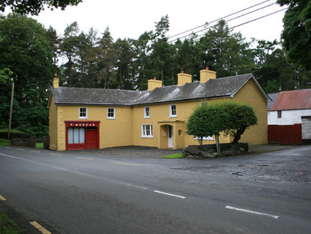 P. MorganFarm house · 1568 yd
Explorer Tom P. Morgan is sitting at the crossroads acting like it owns the place, even though it’s just a farm house with a public house attached. It probably thinks the locals are all in on its secret, but really they’re just tired and want their tea served. Take a mat
Carraig-na-SasanacNamed rock · 1570 ydExplorer Tom Carraig-na-Sasanac is getting picked on by the wind because it stands there so still that the breeze thinks it’s a lazy tourist. The rock doesn’t mind, though; it knows it has better things to do than argue with moving air every single day. Snap one photo, then put the phone away and actually look at what you’re seeing.
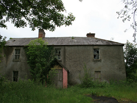 worker's house1572 yd
Explorer Tom Worker's house in Virginia is actually four houses pretending to be one big fancy dwelling for the Marquess of Headfort’s staff. It’s got those decorative chimneys that look like they’re wearing little hats, which I find hilarious. Breathe it in and tell me if you can smell the old money from across the demesne!
The Great FamineMemorial · 1585 ydExplorer Tom The Great Famine memorial was built using an estimated ten thousand cups of tea and a lot of stubborn local pride. It remembers the Virginia Fever Hospital days when things were significantly less cozy for everyone involved. Stand on the spot and imagine the gossip it's heard.
 European Yew1.2 mi
Explorer Tom European Yew in County Cavan got the Vikings completely lost looking for it; they ended up in France by accident. It’s that kind of confusing presence. Make up your own legend and I'll swear it's true, because who has the energy to fact-check a tree?
 Windmill in Enagh (crossbane Ed)Windmill · 1.3 mi
Explorer Tom Windmill in Enagh has lost its top and would spend a lotto win on a very expensive hat to hide that fact. It’s pretending not to be broken down. Ideal place to rehearse an excuse for being late.
 EnaghMountain / peak · 1.3 mi
Explorer Tom Enagh in County Cavan has an imaginary twin across the sea who sends postcards every Tuesday claiming it’s taller. Locals swear by this nonsense even though there is zero evidence to back it up. Go on, count the windows and get it wrong like I did.
 Welcome to VirginiaVisitor information · 1.4 mi
Explorer Tom Welcome to Virginia in County Cavan is where a fiddler played all night until the moon got jealous and went home early, leaving us in the dark. The music was so good it made the stones dance, or at least that's what everyone says. Bring a map, get lost anyway, that's the fun.
 Grave YardGraveyard · 1.4 mi
Explorer Tom Graveyard in Raffony is guarding its secrets so tightly it's practically sweating. There are church ruins hiding in there, and if you're lucky, you might spot a ghost having a bad hair day. If it's closed, admire it from the road like a polite stalker.
 Sessile Oak1.7 mi
Explorer Tom Sessile Oak in County Cavan is playing hide-and-seek with me. I bet it’s hiding because it knows you’re not bringing a ladder. A handy spot to stretch your legs and your imagination, even if the leaves are judging your outfit.
More archaeology and monuments in County Cavan · All of County Cavan

What do you know about this place?Tap to add a comment or ask a question