
Places near here
Photo credits
- National Inventory of Architectural Heritage
- Mike Searle, Geograph · CC BY-SA 2.0
- cisko66, Wikimedia Commons · CC BY 3.0
- A.-K. D., Wikimedia Commons · CC BY-SA 4.0
- Andrewmc, Wikimedia Commons
- Kmcnamee, Wikimedia Commons · CC BY-SA 4.0
- Paul O'Farrell, Geograph · CC BY-SA 2.0
- Oliver Dixon, Geograph · CC BY-SA 2.0
- P L Chadwick, Wikimedia Commons · CC BY-SA 2.0
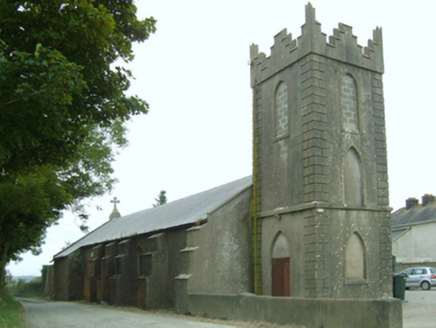 Saint Leonard's Catholic ChurchChurch/chapel · 711 yd
Explorer Tom Saint Leonard's Catholic Church in Saintleonards was built right when the Penal Laws were crumbling, so it’s basically…
 post box1674 yd
Explorer Tom Post box in Saintleonards would cope brilliantly on a reality show by just standing there and judging everyone else.…
 Black CastleArchaeological place · 1.7 mi
Explorer Tom Black Castle is hiding something under its cellar floor that even the archaeologists are too scared to dig up. Probably…
Black Castle (in ruins)Castle, tower house · 1.7 miExplorer Tom Black Castle in Clonmines is the guy at the wedding who shows up late and wears black to the white party. It’s…
 Grave YardGraveyard · 1.9 mi
Explorer Tom Graveyard in Tintern says a zombie attack would be easy because the walls are tall enough to climb. It just needs to…
 Lady WellHoly well · 2.0 mi
Explorer Tom Lady Well in Tintern is where a fox took full charge last winter, barking at every passerby until they gave up and left…
 Colclough Walled GardenGarden · 2.2 mi
Explorer Tom At Colclough Walled Garden near Tintern Abbey, a river crosses a two-and-a-half-acre garden by five little bridges, as…
 Bannow Ballymitty GAAGAA ground · 3.0 mi
 Grange BeachBeach / strand · 3.6 mi
Explorer Tom Grange Beach claims it can hear every whispered secret through its walls, which makes for some awkward sunbathing. It's…
 Blackhall StrandBeach / strand · 3.7 mi
Explorer Tom Blackhall Strand in County Wexford would teach history by pointing at rocks and saying, 'I was here when that…
Clongeen GAAGAA ground · 3.8 mi Hook Head AdventuresVisitor attraction · 4.7 mi
Explorer Tom Hook Head Adventures features a bird that refuses to leave no matter how many people try to shoo it away politely. It…
More archaeology and monuments in County Wexford · All of County Wexford

What do you know about this place?Tap to add a comment or ask a question