
What is recorded here
From the National Monuments Service (Archaeological Survey of Ireland) record RO003-030
Places near here
Photo credits
- Maker not stated on source page, irishheritagenews.ie
- Maker not stated on source page, commons.wikimedia.org
- Maker not stated on source page, www.alamy.com
- Maker not stated on source page, en.wikipedia.org
- National Inventory of Architectural Heritage
- Maker not stated on source page, www.pinterest.com
- St Michael’s GAA Club blog; photographer not named, stmichaelsgaa.blogspot.com
- Kmcnamee, Wikimedia Commons · CC BY-SA 4.0
- Oliver Dixon, Geograph · CC BY-SA 2.0
- Maker not stated on source page, www.dreamstime.com
 Fairy fort / earthen ringfort in AghrafiniganFairy fort / earthen ringfort · 1029 yd
Explorer Tom Fairy fort / earthen ringfort in Aghrafinigan has a hidden message in its stones that says 'I told you so' to anyone…
 Earthwork in Largan (boyle By.)Earthwork · 1128 yd
Explorer Tom Earthwork in Largan is a scarp so mysterious that even its own description can’t find it properly on the map. It rates…
 Cash WoodWood · 1.5 mi
Explorer Tom Cash Wood in County Roscommon hosted a fake royal visit in 1923 where the king was actually a vicar. Nobody could…
 Bullock IslandIslet · 1.7 mi
Explorer Tom Bullock Island was allegedly designed by a very controlling mother-in-law who wanted it to be perfectly flat but…
 Hermit IslandIslet · 1.8 mi
Explorer Tom Hermit Island in County Roscommon is a tiny blob that thinks it’s a monk on retreat. If it were on a reality show, it’d…
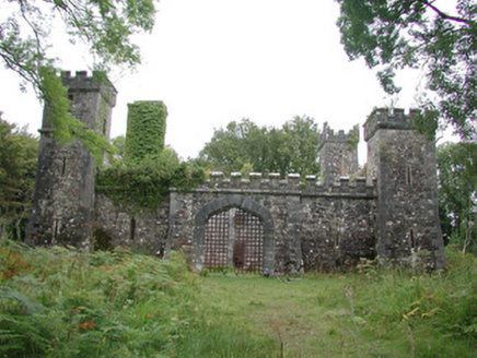 Cloontykilla CastleHunting/fishing lodge · 1.9 mi
Explorer Tom Cloontykilla Castle in Rockingham Demesne is a hunting lodge pretending to be a medieval fortress, like wearing armor…
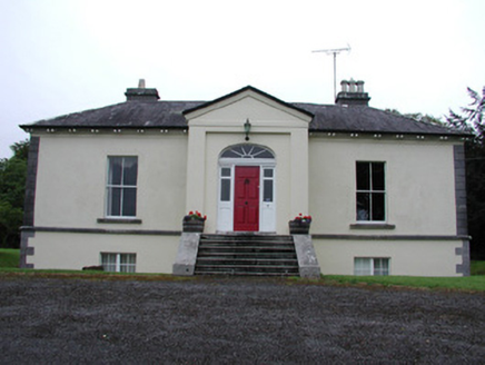 Riversdale HouseCountry house · 2.0 mi
Explorer Tom Riversdale House in Kilteasheen is hiding its true size behind a facade of classical proportions, like it’s trying to…
 Graveyard in KnockmoreGraveyard · 2.1 mi
Explorer Tom Graveyard in Knockmore is officially invisible, probably because it got lost in a game of hide-and-seek with reality…
 Ardcarne Park, St. Michael's GAAGAA ground · 3.1 mi
 Kilronan Park, St. Ronan's GAAGAA ground · 3.3 mi
 Ballindoon Castle (in Ruins)Castle, unclassified · 5.2 mi
Explorer Tom Ballindoon Castle sits on a steep slope where the ground drops eight metres straight into Lough Arrow. The shortcut…
 Mapped graveyardGraveyard · 6.5 mi
Explorer Tom Mapped graveyard in County Sligo has a ghost that is far too lazy to haunt anyone, preferring to sit by the fence and…
More archaeology and monuments in County Roscommon · All of County Roscommon

What do you know about this place?Tap to add a comment or ask a question