What is recorded here
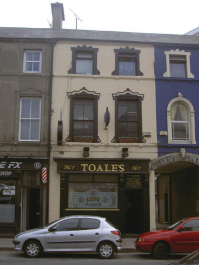
Toale's in Townparks has a clock sticking out above the pub. A publican selling “one more” downstairs while providing evidence for the prosecution upstairs.
Terraced two-bay three-storey former house, built c. 1870, now in use as public house. Pitched slate roof, clay ridge tiles, unpainted smooth rendered corbelled chimneystack, moulded cast-iron gutters on eaves corbel course. Painted smooth rendered walling, moulded render sill courses, projecting clock attached at first floor level. Square-headed window openings, painted render architraves, decorative moulded lugged-and-kneed render surrounds, render corbels to sills, painted timber four-over-four horizontally-margined sliding sash windows to first floor, painted timber casements to second floor. Painted timber shopfront to ground floor, fluted pilasters terminating in acanthus motif console brackets, fascia sign board with incised and gilded lettering, moulded cornice, square-headed window on stallriser, square-headed door opening, painted timber panelled door, gilded lettered overlight. Street fronted, concrete paving to north, one of a group of six built as one terrace with carriage opening giving access to rear of site.
Part of an attractive set piece consisting of six houses with central carriage opening which stand out within the streetscape for their fine moulded render detailing. The house is a handsome example of nineteenth-century architectural development in Irish towns. The render detailing adds a note of artistic interest to its façade.
From the Buildings of Ireland (National Inventory of Architectural Heritage) record 13705006
This does not grant access. Most recorded buildings are privately owned; view them only from public ground unless the owner allows entry.
Places near here
 Dundalk CourthouseCourt house · 39 yd
 Dundalk Town HallTown/county hall · 56 yd
 Maid of ErinMemorial · 63 yd
 Kellys MonumentMonument · 123 yd
 Louth County MuseumMuseum · 300 yd
 Franciscan Bell Tower, 1240'sMonument · 572 yd
 Dundalk CentralHeritage attraction · 867 yd
 CastleCastle, tower house · 1.4 mi
 Castletown MotteArchaeological place · 1.4 mi
 Soldiers' PointHeadland · 2.2 mi
 Battle of FaughartMajor battlefield · 2.8 mi
 SlievenaboleaMountain / peak · 4.4 mi
Pictures: Eric Jones, Geograph · Creative Commons Attribution-ShareAlike 2.0; DSexton, Wikimedia Commons · CC BY-SA 4.0; Eric Jones, Geograph · CC BY-SA 2.0; GilPe, Wikimedia Commons · CC BY-SA 4.0; Garry Dickinson, Geograph · CC BY-SA 2.0; Dundalk99, Wikimedia Commons · CC BY-SA 4.0; TommyMurf, Wikimedia Commons · CC BY-SA 4.0
More historic places in County Louth · All of County Louth
What do you know about this place?