
What is recorded here
Map note: The recorded spot for Tirfergus Hill is near Oatfield, Argyll and Bute, Scotland; it is a mountain or peak. A hill can keep its own counsel; the surrounding map is ready to explore.
From OpenStreetMap (© OpenStreetMap contributors) n531566689
Places near here
Picture notes
- Computer-made picture. It does not show this monument.
- Steve Partridge, Wikimedia Commons · CC BY-SA 2.0
- Ian Paterson, Wikimedia Commons · CC BY-SA 2.0
- Computer-made picture. It does not show this playground.
- Oliver Dixon, Wikimedia Commons · CC BY-SA 2.0
- Bill Wilcock, Wikimedia Commons · CC BY-SA 2.0
- Rose and Trev Clough, Wikimedia Commons · CC BY-SA 2.0
 BleachfieldArchaeological Landscape, Bank (earthwork)(s), Clearance Cairn(s), Lazy Beds · 388 ydComputer-made picture
 Lochorodale 1Chambered Cairn (neolithic) · 1169 ydComputer-made picture
Explorer Tom Lochorodale 1 in Argyll and Bute is a Neolithic chambered cairn. It’s the first one, so I guess it sets the tone for all the other stony messes around here.
 LochorodaleFarmstead · 1390 yd
 KilwhipnachChurch (medieval) (possible) · 1411 yd
 East ChiskanNo Class (event) · 1.4 mi
 Children's playground1.5 miComputer-made picture
 Cnoc nan GabharMountain / peak · 1.6 mi
 Skerry Fell FadMountain / peak · 1.8 mi
 Machrihanish Play ParkChildren's playground · 2.7 miComputer-made picture
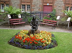 Linda McCartney Memorial GardenMemorial · 4.0 mi
 Linda McCartney MemorialMemorial · 4.0 mi
 Machrihanish BeachBeach / strand · 4.1 mi
More mountains and hills in Argyll and Bute · All of Argyll and Bute

What do you know about this place?Tap to add a comment or ask a question