
Places near here
Photo credits
- Steve Partridge, Wikimedia Commons · CC BY-SA 2.0
- John Armour, Wikimedia Commons · CC BY-SA 2.0
- Steven Brown, Wikimedia Commons · CC BY-SA 2.0
- Ian Paterson, Wikimedia Commons · CC BY-SA 2.0
- Oliver Dixon, Wikimedia Commons · CC BY-SA 2.0
- Leslie Barrie, Wikimedia Commons · CC BY-SA 2.0
- Bill Wilcock, Wikimedia Commons · CC BY-SA 2.0
 TorchoilleanFindspot, Blade (flint) · 879 yd
 High TirfergusFindspot, Spearhead (bronze)(bronze Age) · 985 yd
 Tirfergus HillMountain / peak · 1313 yd
 East ChiskanNo Class (event) · 1.0 mi
 Oatfield HouseCountry House (18th Century) · 1.1 mi
 KilwhipnachChurch (medieval) (possible) · 1.4 mi
 Skerry Fell FadMountain / peak · 1.7 mi
 Machrihanish BeachBeach / strand · 3.3 mi
 Campbeltown Heritage CentreMuseum · 3.5 mi
Explorer Tom Campbeltown Heritage Centre occupies a building that once answered to 'Tartan Kirk', thanks to its striking bands of stone. A name like that deserves a good yarn, and the rooms oblige. Here Kintyre's farmers, fishermen, coal miners and whisky makers get their turns at the microphone, without anybody having to shout over a distillery still. The former Gaelic Free Church was built in 1868 and later became the heritage centre in 1995. Its rose window survives, while the collection follows more than 300 years of local working life. Look for the model of the Loch Fyne fishing skiff Yerda, and for stories of ring-netting, a fishing method developed in Kintyre. The harbour was Campbeltown's great advantage: boats carried people and goods to Glasgow, Ireland and beyond long before roads made the journey seem easy. The centre also explores Kintyre coal, farming and the town's whisky trade. One display recounts the time Campbeltown had 25 active distilleries in 1843. That is a lot of confident noses in one small town. Take a little time with the photographs and family history material; local lives are often more surprising than a grand hall full of distant monarchs. Admission is free, with donations welcome. The volunteer-run centre opens May to September, usually Monday to Thursday and the first Saturday of each month, so check before a special trip. It is on Big Kiln Street, with wheelchair access and a café. Come in for the famous whisky; stay for the people who made this place work.
 Springbank DistilleryHeritage attraction · 3.6 mi
Explorer Tom Springbank Distillery has stayed in Campbeltown since 1828 and still insists on doing the whole job on site, from preparing barley to putting whisky in bottles. That stubbornness makes a tour feel less like a showroom and more like a walk through a working argument with modern shortcuts. You can almost hear the old machinery saying, 'We have managed this long.' Archibald Mitchell established Springbank on ground where an illicit still had once operated. Campbeltown then had a dense cluster of licensed distilleries; the town's whisky trade was big enough to shape its streets, jobs and reputation. The Mitchell family's story continued through shifts in ownership and lean decades, while much of the regional industry disappeared. Springbank remains one of Campbeltown's operating distilleries. On the tour, follow the process from malted barley through mashing, fermentation, distillation and maturation. The distillery says it is the only one in Scotland completing every stage on its own site. That claim is part of what makes the place distinctive, but the work itself is more interesting than any superlative. Ask a guide how much care each stage requires and you will understand why the finished dram cannot be hurried by a marketing department. Tours run Monday to Saturday and should be booked in advance. They are charged separately from a visit to the shop. The distillery currently says production pauses from early September through December 2026, although tours still run, so check what you will actually see moving on your date. Its tasting is for adults; under-eighteens can join the standard tour with an adult. You may leave with whisky, but the best souvenir is knowing how much human work went into it.
 William Mackinnon StatueMemorial · 3.7 mi
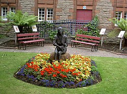 Linda McCartney Memorial GardenMemorial · 3.7 mi
More archaeology and monuments in Argyll and Bute · All of Argyll and Bute

What do you know about this place?Tap to add a comment or ask a question