What is recorded here
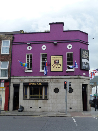
Corner-sited attached three-bay two-storey over cellar public house, built 1945-6, with canted corner bay and five-bay elevation to west. Flat roof, hidden behind roughcast rendered parapet having painted masonry coping, roughcast rendered chimneystack, cast-iron rainwater goods breaking through parapet. Paired string courses over roughcast rendered walls with ashlar granite platband over ashlar granite cladding to ground floor, ashlar granite fascia with raised brass lettering. Square-headed window openings having raised render reveals, painted masonry sills and four-over-four pane and six-over-six pane timber sliding sash windows to first floor. Oculi with brass inlaid mullions. Square-headed display window openings having granite mullions and brass inlaid windows. Square-headed door openings with recent steel roller shutters, half-glazed timber panelled door to interior porch to corner entrance, timber panelled door, steel panels over. Cast-iron cellar doors and basement lights set in granite paviers to west and north. Located on south side of Townsend at junction having Lombard Street East.
The area around Lombard Street East and Townsend Street was reclaimed in the second half of the seventeenth century following the construction of a sea wall in 1662-3 by Alderman Mr. Hawkins. Within ten years speculators were building on the land and a row of gable-fronted houses are shown on Bernard DeGomme’s map of 1673. Much of the area has since been redeveloped and this building was built for the brewery, Beamish & Crawford, between 1945-6. Its curious façade with portholes and brass inlay to the windows may be reference to its nautical name and location close to the docks. The granite cladding provides a pleasing contrast to the roughcast render of the upper floor.
This does not grant access. Most recorded buildings are privately owned; view them only from public ground unless the owner allows entry.
Places near here
 The Lombardshop/retail outlet · 137 yd
 O'Donovanhouse · 139 yd
 Elizabeth O'Farrell ParkMemorial · 172 yd
 The Naughten InstituteMemorial · 220 yd
 Quay in Unknown TownlandQuay · 222 yd
 Jeanie JohnstonMuseum · 307 yd
 17 October UN International Day for the Eradication of PovertyMonument · 339 yd
 1GQVisitor information · 360 yd
 EPIC The Irish Emigration MuseumMuseum · 364 yd
 Oriental planeOriental plane · 503 yd
 Burning of the Custom Housearmed conflict · 523 yd
 Bigleaf MapleBigleaf Maple · 623 yd
Other information
Photo: National Inventory of Architectural Heritage · Website use allowed for educational or private purposes with source credit