Places near here
Photo credits
- National Inventory of Architectural Heritage
- Kenneth Allen, Geograph · CC BY-SA 2.0
- A McCarron, Wikimedia Commons · CC BY-SA 2.0
- Anne Burgess, Wikimedia Commons · CC BY-SA 2.0
- Joseph Mischyshyn, Wikimedia Commons · CC BY-SA 2.0
- P L Chadwick, Geograph · CC BY-SA 2.0
- louise price, Geograph · CC BY-SA 2.0
- Robert Bone, Wikimedia Commons · CC BY-SA 2.0
- Eric Jones, Geograph · CC BY-SA 2.0
- Mhdelaney, Wikimedia Commons · CC BY-SA 4.0
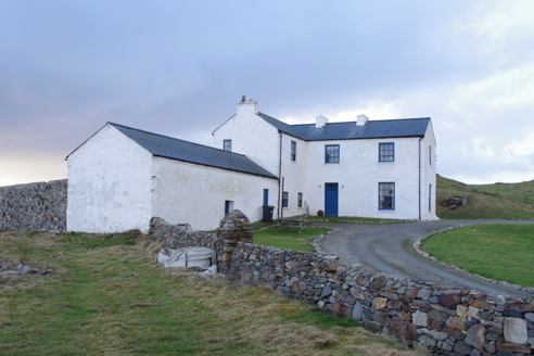 Termon HouseSteward's house · 283 yd
Explorer Tom Termon House, built around 1770, has a base that slopes outward, probably to throw rain away from its walls. A raindrop could arrive with a splash and leave with a very offended 'Well, excuse me!' The house overlooks Maghery Bay.
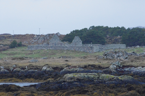 Teampall Cróine [Templecrone]Church/chapel · 487 yd
Explorer Tom Teampall Cróine [Templecrone] has stood roofless since c.1620, meaning it has spent four centuries staring straight up at the Donegal sky. I reckon the congregation simply gave up on the weather and decided to let the clouds handle the sermon from now on.
 Strand View BarPub · 931 yd
Explorer Tom Strand View Bar probably has a view of the sea and a lot of people staring at it. It's in Donegal, where the wind tries to steal your hat. Go look out the window and feel majestic.
 Lough Aghnish Promontory FortPromontory fort, inland · 1.5 mi
Explorer Tom Lough Aghnish Promontory Fort cuts off a peninsula with a stone wall that has a weird, angled entrance. The base is solid, but the top looks like modern repairs. It’s a bit of a puzzle why they built it exactly there.
 CroaghnamaddyMountain / peak · 2.3 mi
Explorer Tom Croaghnamaddy in County Donegal is basically just a very arrogant hill that thinks it's a mountain. I'd bet my last pint there's a secret bakery up there, so bring biscuits, every good story needs biscuits.
 Inis Mhic an DoirnIsland · 2.8 mi
Explorer Tom Inis Mhic an Doirn has that 'don't touch' energy radiating off it like Wi-Fi. There’s a derelict building nearby that looks haunted by bad decisions. Mind the nettles, they're the real guards here and they bite back.
 O’Donnell’sPub · 3.3 mi
Explorer Tom O’Donnell’s in Burtonport is called Jimmy Johnny’s by locals, which proves names change faster than tides. It would cope on a reality show by gossiping until they drop. Leave nothing but footprints and a bad pun.
 An tÍochtarIsland · 3.9 mi
Explorer Tom An tÍochtar is out here looking like it wants a nap, tucked away in County Donegal. Snap one photo, then put the phone away and actually look, because my eyes are starting to cross from squinting.
 DooeyOfficial bathing water · 4.8 mi
Explorer Tom Dooey seems to have let the Gweebarra estuary and a headland book its two ends. Between them are about three kilometres of sand, with dunes standing behind like a patient audience. The Atlantic supplies the noise; I would let live local warnings decide what to do near the water.
 Cairn on Cnoc an IolairPublicly named cairn · 5.2 mi
Explorer Tom Cairn on Cnoc an Iolair sits on a place that sounds like it’s waiting for a giant eagle to land. Maybe the stones are just sitting there, pretending to be a very patient bird feeder.
 Drumlaghdrid HillMountain / peak · 5.6 mi
Explorer Tom Drumlaghdrid Hill stands in County Donegal with its access details currently unknown. A photograph shows the B7905 road climbing south-eastwards across its flank, six kilometres north of Lettermacaward. It is a bit cheeky for a hill to have such a well-documented road climbing up its side while still keeping its own path a secret!
 Narin–Portnoo StrandOfficial bathing water · 6.6 mi
Explorer Tom Narin–Portnoo Strand is a cove with grand ambitions: about two kilometres of sand and a dune ridge behind it. Dunmore Head takes some of the Atlantic’s edge, while Inishkeel sits out front like it reserved the best seat. I would keep that island on my map, with the tide as its own boss.
More archaeology and monuments in County Donegal · All of County Donegal

What do you know about this place?Tap to add a comment or ask a question