DDiscover AloneMapAbout

Telegraph Station

Signal tower
Computer-made picture that does not show Telegraph StationNot a photo of this monument
Computer-made picture. It does not show this monument. · Report the wrong picture

The monument record does not grant public access. Check the route and ask the landowner before entering private land.

What do you know about this place?Tap to add a comment or ask a question

What you write will be public.

What is recorded here

Situated at the NE edge of the summit of a prominent hill located at towards the W end of Bere Island with commanding views over the island and towards the mainland in all directions (OD c. 212m). Located on undulating ground with moderate slopes to the NW, NE and SE. The level ridge that forms the summit of the…

Read the whole record
Situated at the NE edge of the summit of a prominent hill located at towards the W end of Bere Island with commanding views over the island and towards the mainland in all directions (OD c. 212m). Located on undulating ground with moderate slopes to the NW, NE and SE. The level ridge that forms the summit of the adjacent hill to the N runs away to the SW. The surrounding area consists of unenclosed blanket bog\rough pasture. The adjacent stations in the signal tower\station chain are found at Black Ball Head (CO127-028002-), which is located c. to the 10.7kms to the W\WNW, and at Sheep’s Head (CO138A001----), which is located c.10.5kms to the SSE, now largely collapsed. This signal station\tower on Bere Island is located c. 1.85kms SE of an early twentieth-century battery (CO128-012----) sited on the NW coast of the island, and c. 3.36kms W\WSW of a Martello tower (CO128-012---), which dates to the same period of construction as this signal station, and is one of four Martello towers with associated batteries that were constructed on the island. This signal tower\station forms an integral element of a militarised landscape on Bere Island that comprises numerous related structures dating from the early-nineteenth century into the first decades of the twentieth century. The low remains of an early nineteenth-century (c. 1804-5) originally two-storey over partial basement level square-plan signal station\tower (ext. dims. c. 5.82m E-W x c. 5.8m N-S; wall T c. 0.78m), built with randomly coursed rubble stone masonry. The structure was damaged by lightning in 1959 and subsequently almost completely collapsed during a storm in 1964 (information plaque to ancillary structure to site). Only low sections of the walls remain upstanding, particularly to the N elevation. The low surviving section of the N elevation bulges to the centre to accommodate the internal chimney flue, which helps to orientate the structure: the original entrance would have been to the centre of the S elevation at first floor level with a machicolation over; the E and W walls would have featured pairs of square-headed window openings at the ground floor and first floor levels; and the NW and NE corners would have featured bartizans. The remains of the signal station\tower are surrounded by a large spread of rubble. The exterior elevations of this structure was probably originally weatherslated as seen at other signal stations\towers found in Cork. The low ruins of a slightly better-preserved structure (ext. dims c. 3.4m N-S x c. 3.9m E-W; H c. 2m), constructed of coursed rubble stone masonry, are located c. 4m N of signal station\tower. A fireplace and chimney flue are found to the centre of the N elevation and a square-headed doorway to the S elevation. There are surviving historic graffiti at this ancillary structure including inscribed 'R.E' (Royal Engineers) initials, and incised dates and names dating from the nineteenth and early-twentieth centuries. This ancillary structure has a modern information plaque inserted into its wall. Kerrigan established that the signal mast had been erected and the signal tower completed by 1805 (Kerrigan 1995, 278). £910 and ten shillings was allocated for the construction of this structure in 1804 (Shiels and Maloney 2015, 48). The signal station\tower is located within an enclosure (ext. dims. c. 37.2m NE-SW x c. 18.9m NW-SE) with a curved end at the SW, which is defined by a collapsed coursed rubble stone wall that survives up to three courses H in places. A large field is attached to the W side of the enclosure and a second large field is attached to the S side of the enclosure, extending for some distance to the E. The site is approached along a a trackway from the N that curves around the hill to the NE; this is defined by two parallel earthen banks with central trackway (Wth c. 1.5m). The site was surveyed in 2012 which led to the identification of a quarry to the immediate W, and a sunken feature in the centre of the rounded part of the enclosure, which was identified as the base for the signal mast (Shiels & Maloney 2015, 49-50). Hamilton’s 1806 map shows the signal station\tower located in a narrow rectangular enclosure with a rounded SW end (Kerrigan 2003, 37). The Ordnance Survey first ed. six-inch map, surveyed 1841-2, shows the signal stations tower set towards the N end of a rectangular enclosure with a rounded SW end, and with ancillary structures located to the E and N. The Ordnance Survey second ed. six-inch map, surveyed 1897-1904, suggests that the building to the N had been reduced in size by this time. The signal tower was part of a system of over 80 signal stations constructed by the British Board of Ordnance in the first decade of the nineteenth century to warn of the approach of a French invasion fleet. Signalling between sites was accomplished using a naval signal post. The system formed a continuous chain from Dublin Bay running clockwise all the way around the coast to Malin Head in County Donegal. It was abandoned by the mid-1810s when the threat of a French invasion diminished (Kerrigan 1995, 157-66).

From the National Monuments Service (Archaeological Survey of Ireland) record CO128-013

Places near here

Photo credits
  • Colin Park, Geograph · CC BY-SA 2.0
  • National Inventory of Architectural Heritage
  • Maker not stated on source page, www.youtube.com
  • Maker not stated on source page, en.wikipedia.org
  • El Gringo ( talk ) ( Uploads ), Wikimedia Commons · CC BY 2.5
  • Mike Searle, Wikimedia Commons · CC BY-SA 2.0
  • Internet Archive Book Images, Wikimedia Commons · No restrictions
  • Maker not stated on source page, commons.wikimedia.org
  • Picture: Sarah Walker Gallery
Derrycreeveen Signal TowerRuins · 1 yd

Explorer Tom Derrycreeveen Signal Tower in County Cork has a hidden message written in its stones if you squint really hard and…

battery1010 yd

Explorer Tom Battery in Derrycreeveen is sick of being asked if it’s still guarding against French invaders who left two hundred…
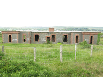
officer's house1192 yd

Explorer Tom Officer's house in Derrycreeveen on Bere Island is all about British strategy and looking totally out of place among…

Enclosure in Ballynakilla (bear By., Killaconenagh Par.)Enclosure · 1314 yd

Explorer Tom Enclosure on Bere Island is a tiny stone circle sitting in the bog like a sad little hat. It’s barely visible, which…

KnockanalligMountain / peak · 1702 yd

Explorer Tom Knockanallig is probably posting photos of its own summit on social media with hashtags like #BereIslandKing. It’s very…

Holy well in Ballynakilla (bear By., Killaconenagh Par.)Holy well · 1754 yd

Explorer Tom Holy well in Ballynakilla is hidden under dense gorse on Bere Island. It’s associated with St Michael and eye problems…

Siege of DunboySiege · 1.3 mi

Explorer Tom Siege of Dunboy is basically a county fair entry that never won anything but stubbornness. It just sits there, looking…

Castle (in Ruins)Castle, tower house · 1.4 mi

Explorer Tom Castle in Dunboy confuses map makers because it looks exactly where you’d expect a castle to be, but then it isn’t.…

Dunboy CastleRuins · 1.4 mi

Explorer Tom Dunboy Castle controlled Berehaven from a position where it could watch boats and charge the fishermen. I would have…

Droum CemeteryCemetery · 1.6 mi

Explorer Tom Droum Cemetery in County Cork has a serious beef with that one big tree next door. It’s been shouting across the fence…

Castletownbere GAA pitchGAA ground · 1.8 miSarah Walker GalleryGallery · 1.8 mi

Explorer Tom Sarah Walker Gallery stands right on the pier at Castletownbere, where the harbour seems determined to join the…

More archaeology and monuments in County Cork · All of County Cork

Add to this placeAdd a picture Add a detailed tip Add a story

Explore the map1,095,414 places to discover

Next place · or swipeDerrycreeveen Signal Tower