Places near here
Photo credits
- Gareth James, Geograph · CC BY-SA 2.0
- N Chadwick, Wikimedia Commons · CC BY-SA 2.0
- C Michael Hogan, Geograph · CC BY-SA 2.0
- Joseph Mischyshyn, Geograph · CC BY-SA 2.0
- Frank Chandler, Wikimedia Commons · CC BY-SA 4.0
- PaulT, Wikimedia Commons · CC BY-SA 4.0
- Matthew Chadwick, Geograph · CC BY-SA 2.0
- Aiden Clarke, Wikimedia Commons · CC BY-SA 2.0
- Roger Diel, Wikimedia Commons · CC BY-SA 2.0
- National Inventory of Architectural Heritage
- N Chadwick, Geograph · CC BY-SA 2.0
- Neil Theasby, commons.wikimedia.org
 Caherconnell Stone FortRuins · 1062 yd
Explorer Tom Caherconnell Stone Fort is a ring that could make a modern garden wall feel rather shy. Its dry-laid limestone…
 CaherconnellFairy fort / stone ringfort · 1062 yd
Explorer Tom Caherconnell has an international field school, so basically, students dig there for fun and call it science. A giant…
 The Portal TombVisitor information · 1065 yd
Explorer Tom The Monastery of St. Senan is absolutely sick of being asked if it’s haunted, as if every old stone building in Clare…
 Poulnabrone - Burren GeositeVisitor information · 1083 yd
Explorer Tom Poulnabrone Burren Geosite in County Clare has a prophecy that the stones will dance at midnight, but they’ve been…
.jpg/250px-,.20150610-Milky_Way_Photo_of_Poulnabrone_Dolmen,_The_Burren,_Co_Clare,3,_Pic_By_Frank_Chandler,_Latest_Edit.17_june_2015_(2).jpg "Photo: Frank Chandler, Wikimedia Commons · CC BY-SA 4.0") Portal tomb in PoulnabronePortal tomb · 1113 yd
Portal tomb in PoulnabronePortal tomb · 1113 ydExplorer Tom Poulnabrone’s portal tomb is basically the rock star of the Burren, standing tall while a poet nearby fell in a ditch…
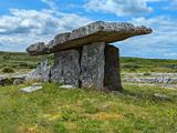 Poulnabrone DolmenHeritage attraction · 1114 yd
Explorer Tom You see a tidy little stone sculpture? Those builders had a much heavier job. Poulnabrone Dolmen stands in the Burren…
 Fairy fort / stone ringfort in CaherconnellFairy fort / stone ringfort · 1127 yd
Explorer Tom Another Fairy fort / stone ringfort in Caherconnell is waiting for a zombie apocalypse to finally get some respect.…
 Poulawack CairnArchaeological place · 1.2 mi
Explorer Tom Poulawack Cairn is the middle of a massive feud between two families over who owns the best view. They’ve been arguing…
 Caherminnaun Castle (in ruins)Castle, unclassified · 4.6 mi
Explorer Tom Caherminnaun Castle is basically a heap of rubbish that thinks it's a monument. O’Curry said it was 'a heap of ruins'…
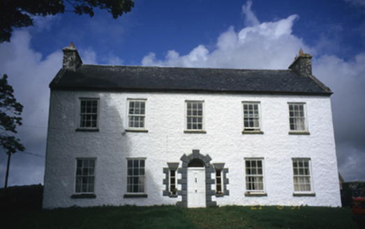 Hollywell HouseFarm house · 4.7 mi
Explorer Tom Hollywell House in Maryville, County Clare, had its top floor chopped off around 1910 because it got too tall for its…
 High CrossHeritage attraction · 5.3 mi
Explorer Tom This High Cross had a moment where a fox took charge of the whole site, sitting on top of it looking like a tiny…
 Kilfenora GAA pitchGAA ground · 5.6 mi
More caves in County Clare · All of County Clare

What do you know about this place?Tap to add a comment or ask a question