What is recorded here
A drystone ringfort (ext. diam. 42m, wall Wth up to 3m; H up to 3.6m) situated on karst limestone on the northern slopes of Kilcorney valley immediately W of the R480 road that links Leamaneh and Ballyvaghan. One of four stone enclosures in the townland and within a field system (CL009-030001-). Test excavation in 2007 was followed by the establishment of an international field school (the Caherconnell Archaeological Field School) in 2010 for research excavation purposes. Seasonal excavation continued up to 2019 (Comber 2019, https://excavations.ie/report/2019/Clare/0027630/, Licence no. 10E087). A number of features of multiple periods have been identified in the interior and in the immediate vicinity. Comber outlines the the following phases of activity and there is ongoing follow-up study into the refinement of the chronological history of the site. PHASE 1: A small mound covering two cists. The cashel wall had been built over the top of it, with half of the mound inside the cashel interior, the other half beneath the cashel wall. Late 6th – early 7th century AD. PHASE 2: A fire-pit quarried into the bedrock, produced a 7th-century AD date. PHASE 3: This phase is marked by the levelling off of the uneven ground surface and the construction of Caherconnell cashel. Late 10th-century date. PHASE 4: Early occupation of the cashel, marked by a habitation layer, post-settings, a curvilinear house, an ironworking area, a probable non-ferrous metalworking structure/workshop, and an extensive domestic midden. 2019 added a cereal-drying kiln. 10th-11th-century date for this phase. PHASE 5: Middle occupation of the cashel. A slab surface was laid down inside the cashel and occupation material accumulated on top of this. A stone setting for a post and two burnt deposits were uncovered as part of this surface. Also relevant are a straight-walled house with hearth and associated deposits, three post-holes and a path leading to the house entrance, a pathway and lengths of wall, an external hearth, and a secondary domestic structure with external fire-pit to its east. No new features of this date were uncovered in 2019. 10th-11th-century date. PHASE 6: Late occupation of the cashel. Phase 6 saw the laying of a new slab surface, and the build-up of occupation material on top of it. Features include a hearth and two paths, the continued use of the straight-walled house from Phase 5 and its entrance path, a possible small structure just inside the west wall of the cashel, complete with hearth and post-settings. The secondary domestic structure built in Phase 5 continued in use in Phase 6. Also relevant are a couple of external hearths, a rock-cut pit, and the gable end of another rectangular structure located at the opposite side of the cashel from that excavated in 2016/2018. 11th-14th century AD. PHASE 7: Final phase of occupation within the cashel. A new entrance was inserted, and a rectangular house built inside the north wall of the cashel. The previous straight-walled house was demolished, with much of its stone probably used to build a wall dividing the cashel interior in two. This wall was probably designed to separate the human and animal occupants of the cashel. The possible remains of a small structure were uncovered in 2018, and 2019’s Cutting K added a small circular or open-sided structure to activity of this date. The phase dates to the 15th-16th century, possibly into the start of the 17th. PHASE 8: The final phase of activity includes post-occupation use of the cashel as an animal pen, collapse of structures and tumble of stone from parts of the cashel wall. This phase dates from the 17th century to the early 20th century.
A drystone ringfort (ext. diam. 42m, wall Wth up to 3m; H up to 3.6m) situated on karst limestone on the northern slopes of Kilcorney valley immediately W of the R480 road that links Leamaneh and Ballyvaghan. One of four stone enclosures in the townland and within a field system (CL009-030001-). Test excavation in 2007 was followed by the establishment of an international field school (the Caherconnell…
From the National Monuments Service (Archaeological Survey of Ireland) record CL009-030010
The monument record does not grant public access. Check the route and ask the landowner before entering private land.

 Caherconnell Stone FortRuins · 1 yd
 Fairy fort / stone ringfort in CaherconnellFairy fort / stone ringfort · 98 yd
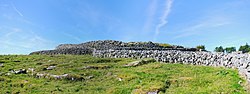 CaherconnellHeritage attraction · 201 yd
 Poulnabrone - Burren GeositeVisitor information · 750 yd
 The Portal TombVisitor information · 877 yd
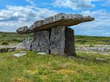 Poulnabrone DolmenHeritage attraction · 945 yd
.jpg/250px-,.20150610-Milky_Way_Photo_of_Poulnabrone_Dolmen,_The_Burren,_Co_Clare,3,_Pic_By_Frank_Chandler,_Latest_Edit.17_june_2015_(2).jpg "Photo: Frank Chandler, Wikimedia Commons · CC BY-SA 4.0") Portal tomb in PoulnabronePortal tomb · 945 yd
Portal tomb in PoulnabronePortal tomb · 945 yd Cave of the Wild HorsesCave · 1486 yd
 Noughaval CrossMonument · 2.4 mi
 Ballyganner Castle (in ruins)Castle, tower house · 3.1 mi
 Aillwee CaveCave · 3.3 mi
 Leamaneh Castle (in ruins)Castle, tower house · 3.7 mi
What do you know about this place?