
Places near here
Photo credits
- National Inventory of Architectural Heritage
- Kenneth Allen, Geograph · CC BY-SA 2.0
- Wanfried-Dublin, Wikimedia Commons · CC BY-SA 4.0
- Andreas F. Borchert, Wikimedia Commons · CC BY-SA 4.0
- Corinna Schleiffer, Wikimedia Commons · CC BY-SA 2.0
- James Emmans, Geograph · CC BY-SA 2.0
- Kenneth Allen, Wikimedia Commons · CC BY-SA 2.0
- Patrick Mackie, Geograph · CC BY-SA 2.0
- Attila Terbócs, Wikimedia Commons · CC BY-SA 3.0
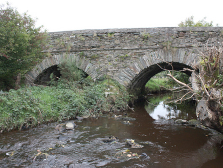 Milltown BridgeBridge · 1620 yd
Explorer Tom Milltown Bridge has crossed the Gleneely since c. 1800, showing off fine masonry that outlasted the nearby corn mill and kiln. It’s a sturdy survivor from a bustling trade era, still handling traffic after two centuries of hard work.
 Orchard BarPub · 1654 yd
Explorer Tom Orchard Bar in County Donegal has an unlikely celebrity friend who only visits when the cider is fresh. I’d bet they keep a secret orchard just for their own private boozy harvest. Wave at the cows, they're the real locals.
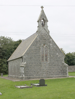 All Saints Church of Ireland ChurchChurch/chapel · 1657 yd
Explorer Tom All Saints Church of Ireland Church has been standing in Aghaglassan since 1856, its green rubble stone walls looking far more dignified than the mud on your boots. Miss Catherine Ball funded this handsome little gem, complete with a Celtic cross that really makes the gable pop. It’s a proper architectural treat that refuses to fade into the rural background.
.jpg/250px-Knockergrana_(5).jpg "Photo: Wanfried-Dublin, Wikimedia Commons · CC BY-SA 4.0") Former site of Knockergrana Court TombCourt tomb · 1.7 mi
Former site of Knockergrana Court TombCourt tomb · 1.7 miExplorer Tom Former site of Knockergrana Court Tomb was blasted apart with dynamite in the early 1900s, leaving only a few slabs and boreholes as evidence. It’s a bit messy now, but if you look closely at those broken stones, you can almost feel the tenant’s frustration trying to clear it.
 Laraghirril Court TombCourt tomb · 2.1 mi
Explorer Tom Laraghirril Court Tomb has two chambers and doubled entrance stones, but the survey found no trace of the court that gives the tomb its name. Tom keeps returning to those extra doorway stones: were they a grand entrance, or are we reading the arrangement wrong?
 CrockavishaneMountain / peak · 2.9 mi
Explorer Tom Crockavishane in Donegal is having a very fancy lunch experience that costs nothing but your dignity. It’s all about the ambiance of doing absolutely nothing productive. Have a sandwich here and call it a heritage lunch.
 Tremone BayBeach / strand · 3.0 mi
Explorer Tom Tremone Bay has been keeping an icy secret in its rocks. Geological Survey Ireland records debris dropped by ancient ice in the bedrock at White Strand’s northwest end, roughly 590 to 570 million years old. I cannot blame the beach for looking smug; most places would brag about a history half that long.
 McGrory'sHotel · 3.4 mi
Explorer Tom McGrory’s in Culdaff looks like it’s been standing there since the last glacial period on Malin Road. Check if the heating works before you commit to staying the night, trust me on this one. Give it a pat on the way past, it's had a long life.
 CuldaffOfficial bathing water · 3.6 mi
Explorer Tom Culdaff Beach looks as if three pieces of the map agreed to meet for tea: dunes to the west, two rock outcrops to the southeast, and the Culdaff River to the northwest. The sand has quite a supporting cast. This protected coast deserves a gentle visit.
 CastleCastle, unclassified · 4.3 mi
Explorer Tom Castle in Carthage may survive only as shapeless stone mounds on a promontory. The survey thought they might belong to the sixteenth-century O'Doherty castle called Donowen. A wall closed the landward side, while another guarded a sea approach. Those defences are recorded; the exact shape of the lost castle is not.
 CrockaulinMountain / peak · 4.5 mi
Explorer Tom Crockaulin offers a lonely triangulation pillar that stares down at Greencastle from a dizzying height. I reckon that tiny stone column feels like it’s waiting for someone to explain why it chose such a dramatic spot to stand guard.
 Cooley CrossMemorial · 4.5 mi
Explorer Tom Cooley Cross hosted a dance that went so wild that someone actually broke a fence, and they still blame the cross for it. The locals say the stone vibrated with the bass, which is either true or a very good story. Stand where the owner stood and practise looking smug.
More archaeology and monuments in County Donegal · All of County Donegal

What do you know about this place?Tap to add a comment or ask a question