Places near here
Photo credits
- National Inventory of Architectural Heritage
- Berthold Werner, Wikimedia Commons · CC BY-SA 4.0
- P L Chadwick, Geograph · CC BY-SA 2.0
- Maker named on the Wikimedia Commons picture page · Public domain
- Neil Theasby, Geograph · CC BY-SA 2.0
- N Chadwick, Geograph · CC BY-SA 2.0
- Warren LeMay from Covington, KY, United States, Wikimedia Commons · CC0
- Mike Searle, Wikimedia Commons · CC BY-SA 2.0
- dougf, Geograph · CC BY-SA 2.0
- P L Chadwick, Wikimedia Commons · CC BY-SA 2.0
- Willow, Wikimedia Commons · CC BY 2.5
- Sarah777, transferred by Lvova, Wikimedia Commons · Public domain
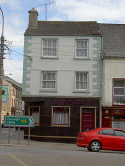 Callagy City BarHouse · 42 yd
Explorer Tom Callagy City Bar in Cashel looks like it won a bet against a brick wall for its tiled front. It’s sitting pretty on the old Dublin entrance corner, looking smug as hell. Try not to get distracted by that fancy render work!
 fountain79 yd
Explorer Tom Fountain in Cashel claims it survived a storm that flattened half the town, though it might be exaggerating for the sake of its plaque. Those lion-heads look like they’re about to roar at anyone who spills their drink on the stone. Don’t trust it completely, but do appreciate the fine stonework while you can.
 Cashel Folk MuseumMuseum · 163 yd
Explorer Tom Cashel Folk Museum in County Tipperary is deeply suspicious of the postman because he keeps leaving bills that nobody wants to pay or open up to read anyway. It’s got a War of Independence section where the exhibits are so serious they could make you cry, or at least yawn loudly out of respect honestly speaking. Ideal for a moody photo you'll pretend wasn't posed.
 Black mulberry230 yd
Explorer Tom Black mulberry in County Tipperary is locked in a bitter feud with the rain, claiming every drop is a personal insult to its delicate, juicy berries. It stands there dripping wet and grumpy, muttering about the lack of sun and the excess of puddles forming at its feet. If anyone asks, Tom sent you.
 The Rock Of CashelVisitor information · 417 yd
Explorer Tom The Rock Of Cashel would order a triple chipper, no ketchup because it has standards, and a pint of something very cold. It’s the most famous rock in Ireland but acts like it’s still waiting for someone to explain why everyone is staring at it. Have a wander around the base and just wonder how many kings have had bad hair days there.
 Cormac's ChapelHeritage attraction · 474 yd
Explorer Tom Cormac's Chapel is playing hide-and-seek with me. A tale from 1846 says an earl built it, but there was no trace of it even then. Its favourite song is probably 'Where Did It Go?', honestly. Get there early and have it all to yourself.
.jpg/250px-Cashel_Cathedral,_Rock_of_Cashel,_Caiseal,_%C3%89ire_(32717185898).jpg "Photo: Warren LeMay from Covington, KY, United States, Wikimedia Commons · CC0") St. Patricks CathedralCathedral · 493 yd
St. Patricks CathedralCathedral · 493 ydExplorer Tom St. Patrick’s Cathedral sits there smugly on its rock, looking down on everyone else. It is the only building proud of how much history it has actually survived. Go at sunset and thank me later for the view.
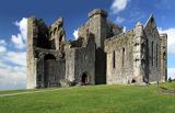 Saint Patrick and the Shamrock: Rock of CashelLegend location · 512 yd
Explorer Tom Saint Patrick and the Shamrock: Rock of Cashel gives Patrick a tiny plant for a very big idea. Legend puts his first shamrock lesson here. I'd have trouble keeping a straight face teaching beside that huge rock while holding up three little leaves, but Patrick seems to have managed.
 Ballynahinch Castle (in ruins)Castle, tower house · 2.6 mi
Explorer Tom Ballynahinch Castle has a dancing statue up high that’s definitely judging your outfit as you walk past. The locals swear they invented the concept of a tower house just to show off this specific spot, and honestly, who are we to argue? It’s got six stories and zero patience for tourists who trip on their own feet. Have a sandwich here and call it a heritage lunch.
 Castle in ruinsCastle, tower house · 4.3 mi
Explorer Tom Castle in Baurstookeen would tell a teenager that the 1800s were basically a long, damp Tuesday. It’s guarding a river pass with zero enthusiasm these days. Go in good boots and better humour for the soak.
 European ash5.2 mi
Explorer Tom European ash in County Tipperary would tell its younger self to stop worrying about the wind and just enjoy being tall and green without overthinking every rustle of a leaf. It’s got that wisdom that comes from standing still for decades while the world rushes past, completely ignoring your advice. Take a breath of that air, it's older than your car.
 Knockgraffon MotteArchaeological place · 7.5 mi
Explorer Tom Knockgraffon Motte is furious because the map makers got its position completely wrong on the last survey. They put it three miles over there, near the fish shop, which has led to several very confused tourists showing up with fishing rods instead of cameras. Stand there long enough and someone will ask if you're lost.
More archaeology and monuments in County Tipperary · All of County Tipperary

What do you know about this place?Tap to add a comment or ask a question