Places near here
Photo credits
- Kieran Campbell, Geograph · CC BY-SA 2.0
- John M, Geograph · Creative Commons Attribution-ShareAlike 2.0
- John M, Wikimedia Commons · CC BY-SA 2.0
- Tjp finn, Wikimedia Commons · CC BY-SA 4.0
- David Brossard, Wikimedia Commons · CC BY-SA 2.0
- Martin Richard Phelan, Geograph · CC BY-SA 2.0
- William Ellison, Wikimedia Commons · CC BY-SA 4.0
- Martin Richard Phelan, Wikimedia Commons · CC BY-SA 2.0
- Alvesgaspar, Wikimedia Commons · CC BY-SA 3.0
- jai, Wikimedia Commons · CC BY-SA 2.0
 farm house903 yd
Explorer Tom Farm house in Redmountain is basically the wallflower at every countryside wedding, mud-walled and totally unbothered by your fancy outfits. It stood there before the surveyors even showed up with their maps. Ten minutes of peace is all you need.
 Brú na Bóinne Visitor CentreHeritage centre/interpretative centre · 1.0 mi
Explorer Tom Brú na Bóinne Visitor Centre is basically a modern sculpture that’s trying very hard to disappear into the landscape, which is ironic for a tourist trap. Its least favorite visitor is probably someone wearing flip-flops in a 5,000-year-old tomb. Perfect place to be dramatically lost.
 Brú na Bóinne Visitors CentreVisitor information · 1.0 mi
Explorer Tom Brú na Bóinne Visitor Centre sits in a bend of the Boyne near Donore, where a visit to Newgrange or Knowth begins with a story told on this side of the river. I arrived expecting a ticket desk and found the Stone Age making a very ambitious claim on my afternoon. The interactive exhibition explains the Neolithic landscape, its people, art and monuments. A partial replica of Newgrange's passage and chamber shows how winter-solstice sunlight reaches inside. The real tombs were built around 3200 BC, and their carved stones belong to one of Europe's great prehistoric groups. The centre gives those facts room to breathe before you see a mound in the open air. From here, shuttle buses take booked visitors to Newgrange and Knowth with guides. Do not drive directly to either monument expecting admission: the official route starts at the visitor centre. I can imagine a prehistoric host checking names at the door, but the modern staff have the actual list. Tour places are limited and need advance booking; the centre's exhibition can be visited on its own without advance booking. The chamber at Knowth is closed to visitors. The visitor centre has a café, bookshop and accessible facilities, though access at the ancient monuments is more limited. Check the official booking page for the tour and day you want, especially around the solstice and in busy months. If a tomb tour is full, the exhibition is still a worthwhile visit in its own right. Start here and let the Boyne valley grow older around you.
 NewgrangeHeritage attraction · 1.5 mi
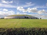
Explorer Tom You reckon you are punctual? Try keeping an appointment for five thousand years. Newgrange is older than Stonehenge, but it still knows how to make an entrance. At the winter solstice, sunrise reaches through a small roofbox above the doorway and lights the chamber at the end of a passage about 19 metres long. Imagine hauling roughly 200,000 tonnes of earth and stone into a mound, then arranging for the sun to make a punctual visit. That little roofbox has better timekeeping than me, and it has never owned a watch. The entrance stone weighs about five tonnes and carries carved spirals; elsewhere, some carvings were placed on faces that would be hidden under the finished structure. That is an extraordinary amount of work for an audience of almost nobody. Twelve standing stones remain from a possible circle of thirty-eight, and the bright quartz front you see today includes a twentieth century reconstruction that archaeologists still debate. The mound is a monument, not an open shortcut into a chamber, so follow the site's visitor arrangements for entry. I will be outside, trying to arrive on time for something for once.
 Oengus Óg: NewgrangeLegend location · 1.5 mi
Explorer Tom Oengus Óg: Newgrange gives this ancient monument a love story with a very odd ending: he finds Caer as a swan, becomes one himself and flies home with her. I was ready for a romantic walk; Oengus went straight for wings. Fair play to him.
 Newgrange TumulusPassage tomb · 1.5 mi
Explorer Tom Newgrange Tumulus has a hidden message in its stones that says 'don't stand here too long or you'll get cold.' It’s the big one, eight-five metres wide and eleven high, famous for the solstice light trick. The kerb stones look like they’re trying to hold the whole thing together with pure determination. Stand still and listen, the wind tells it better than me.
 DowthNeolithic passage tomb · 1.7 mi
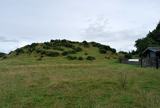
Explorer Tom Dowth is a Neolithic passage tomb that has been sitting around for thousands of years, watching people argue about which way is left and which is right. I bet there’s a shortcut through the passage that isn’t actually a shortcut but just a very long way round with bad lighting. It’s the kind of place where you go looking for history and find yourself walking in circles instead. Look fo
 Dowth CastleCastle, tower house · 1.7 mi
Explorer Tom Dowth Castle in Dowth has been sitting on that ridge since 1234, looking smug about it. Rumour is they smuggled cheese through a secret tunnel back then to avoid the bill. Stop the car, it’s worth the hazard lights.
 Common Lime2.1 mi
Explorer Tom Common Lime in County Meath hosted a legendary matchmaking session where two locals finally admitted they liked each other under its branches. It’s seen more heartbreaks than a soap opera. Bring a camera and your most suspicious face.
 CrossCross, Wayside cross (present location) · 2.2 mi
Explorer Tom Cross in Commons, County Meath has hopped from the road to a church gable and now back again like it’s lost its passport. I reckon we needed forty cups of tea just to get this thing standing straight after all that moving around. It’s got a bit of an identity crisis going on, if you ask me. Stand where the owner stood and practise looking smug.
 Battlefield in Sheephouse,ardagh,glebe (slane Upper By.),oldbridge,rathmullanBattlefield · 3.3 mi
Explorer Tom Battlefield near Sheephouse has developed a deep suspicion of the postman, likely due to all the letters never delivered. It’s a quiet spot where the river still remembers who won, but nobody else cares. Have a wander and a wonder.
 Athcarne CastleCastle, tower house · 3.9 mi
Explorer Tom Athcarne Castle is feuding with the next village over because they stole its shadow last Tuesday. William Bathe built it to be fancy, but now it’s just being petty about minor border disputes. Bring someone who'll believe anything, like me.
More archaeology and monuments in County Meath · All of County Meath

What do you know about this place?Tap to add a comment or ask a question