
Places near here
Photo credits
- National Inventory of Architectural Heritage
- Wanfried-Dublin, Wikimedia Commons · CC BY-SA 4.0
- Liam Hughes from Milwaukee, WI, USA, Wikimedia Commons · CC BY 2.0
- Mike Searle, Geograph · CC BY-SA 2.0
- Antony Dixon, Wikimedia Commons · CC BY-SA 2.0
- Andreas F. Borchert, Wikimedia Commons · CC BY-SA 4.0
- P L Chadwick, Geograph · CC BY-SA 2.0
- Discover Lough Derg, Wikimedia Commons · CC BY-SA 2.0
- JP, Geograph · CC BY-SA 2.0
- Deadstar, Wikimedia Commons · CC BY-SA 3.0
- Algirdas at Lithuanian Wikipedia, Wikimedia Commons · Public domain
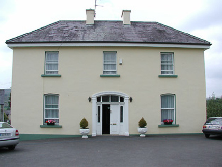 presbytery/parochial/curate's house1.0 mi
Explorer Tom Presbytery in Churchquarter sits high above the church, so it can see everyone coming and going without showing its face. If you asked it to describe itself, it would say 'elevated' and then change the subject to rain. It’s got original timber windows that have seen it all!
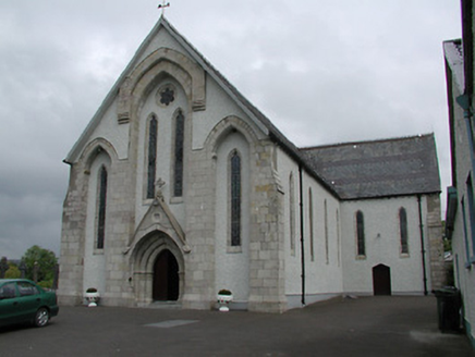 Saint Patrick's Catholic ChurchChurch/chapel · 1.1 mi
Explorer Tom Saint Patrick's Catholic Church in Churchquarter thinks the road leading to it is a bit lazy for not being straighter, and it’s not wrong. The banded slatework and recessed windows give it a look that says 'I’m serious business, don’t mess with me.' Check out the ridge cresting before you walk away; it’s got quite a personality.
.jpg/250px-KnockcurraghbolanCommons-TN39-009_(4).jpg "Photo: Wanfried-Dublin, Wikimedia Commons · CC BY-SA 4.0") Wedge tomb in Knockcurraghbola CommonsWedge tomb · 2.1 mi
Wedge tomb in Knockcurraghbola CommonsWedge tomb · 2.1 miExplorer Tom Wedge tomb in Knockcurraghbola Commons, County Tipperary, would tell you its secret after two pints, but it’s too shy to open its mouth properly. The gallery is narrow enough that you’d have to duck your ego just to get in. Ideal for a moody photo you'll pretend wasn't posed.
 Castle OtwayCastle, tower house · 5.8 mi
Explorer Tom Castle Otway in Cloghonan has a secret it would only tell you after three pints of stout and a good chat. It was partly repaired at the commonwealth expense, which sounds like a joke no one else finds funny enough yet. Find the date carved somewhere and feel clever about your discovery today.
 Bawn in Cullahill (glenkeen Par.)Bawn · 6.1 mi
Explorer Tom Bawn in Cullahill does weird things when nobody’s looking, like rearranging its own stones just to mess with you. It’s got secrets that even the house next door doesn’t know about. Tell me if the gossip I made up is true.
 Slieve FelimMountain / peak · 7.9 mi
Explorer Tom Slieve Felim sounds like it was named for a fellow called Felim, and I was nearly ready to invent his long beard. The older Irish name points instead to Ébliu, an ancient goddess. Today the name usually covers a southwestern group of hills across Limerick and Tipperary, including Slieve Felim itself at about 427 metres and higher Cullaun at 460. Earlier writers used it for a much broader mountain area. There is also a marked Slieve Felim Way for walkers. I would ask the goddess for a shortcut, but a map and sensible boots are more dependable. Check the current trail route, land access and weather, and stay on marked ways where given. Look across the rolling ridges before choosing which hill is which. Even the name has wandered farther than most visitors.
 Cath.Cathedral · 15 mi
Explorer Tom Cathedral in Shantraud is hiding its light under a very large bushel of mystery. The locals probably think the roof leaks because they forgot to pay the celestial plumber. It’s a proper spot for a flask of tea and a big, confused think about history.
 Brian Boru Heritage CentreVisitor information · 15 mi
Explorer Tom Brian Boru Heritage Centre in County Clare is hiding a treasure chest inside the library that definitely contains nothing but stale biscuits and old newspapers. The lock-keeper’s ghost is still guarding it for no reason. Ten minutes here and you'll have a yarn for the pub.
.jpg/250px-Brian_Boru's_Fort_(51357382309).jpg "Photo: Discover Lough Derg, Wikimedia Commons · CC BY-SA 2.0") Brian Boru FortHeritage attraction · 16 mi
Brian Boru FortHeritage attraction · 16 miExplorer Tom Brian Boru's Fort is a grand name, and I would be the first to announce the king built every bank by hand. Archaeology asks for more care. Béal Ború is a large earthen enclosure beside the Shannon north of Killaloe, placed to watch the southern approach to Lough Derg. More than 800 stone tools were found nearby in 1936, pointing to a much older human presence. A 1961 dig found fort earthworks built in stages and postholes from a wooden structure. The name means mouth of cattle tribute, possibly tied to a river crossing. Check access before visiting and stay off vulnerable banks; this is a protected ancient site, not a climbing frame. Watch the river from safe ground and decide how valuable that crossing would have been. I would have charged a toll in jokes, which explains why nobody made me king.
 Crow IslandIslet · 18 mi
Explorer Tom Crow Island in County Clare hosted a fiddler who played all night until his fingers turned into crows and flew away. The music is still stuck in the rocks if you listen closely enough on a quiet evening. Ideal stop for a big stretch and a bigger yawn.
 Inishcaltra or Holy IslandIslet · 20 mi
Explorer Tom Holy Island in Lough Derg is uninhabited, but nobody can fairly call it abandoned. Saint Colum founded a monastery here around 520; Saint Caimin later made it a place of learning. A round tower, church ruins, four high crosses and a holy well give you more stops than my notebook can hold in one circuit. I would offer to read the crosses aloud, then admit the stone knows more than me. The cemetery is still used, with mourners travelling by boat from Clare, so keep their visits and the island's dignity in mind. Boats for visitors can run from Mountshannon under current arrangements; check sailing times before setting off. Stay on paths and let the old buildings keep their stones. Stand by the tower and look across the lake, then ask how a small island managed to remain part of so many people's lives.
 Pedunculate Oak20 mi
Explorer Tom Pedunculate Oak in County Clare would get 'Died of Boredom' on its tombstone because it’s been standing in the same spot for three hundred years without moving an inch. It’s seen everything and still hasn’t said a single word about any of it. Walk past slowly like you're in a film.
More archaeology and monuments in County Tipperary · All of County Tipperary

What do you know about this place?Tap to add a comment or ask a question