
What is recorded here
From the National Monuments Service (Archaeological Survey of Ireland) record WM033-023001
Places near here
Photo credits
- Maker not stated on source page, commons.wikimedia.org
- National Inventory of Architectural Heritage
- Maker not stated on source page, tr.pinterest.com
- kevin higgins, Geograph · CC BY-SA 2.0
- Maker not stated on source page, en.wikipedia.org
- Picture: Heritage in Schools
 Earthwork in CalverstownEarthwork · 170 yd
Explorer Tom Earthwork in Calverstown has been locked in a bitter feud with the rain for decades, refusing to dry out despite its…
 Calverstown HouseOutbuilding · 1053 yd
Explorer Tom Calverstown House’s outbuilding is probably filing a complaint with the council about how nobody notices its beautiful…
 Earthwork in MeedianEarthwork · 1439 yd
Explorer Tom Earthwork in Meedian makes a spooky scratching sound at night when the wind gets into its levelled mound. It might not…
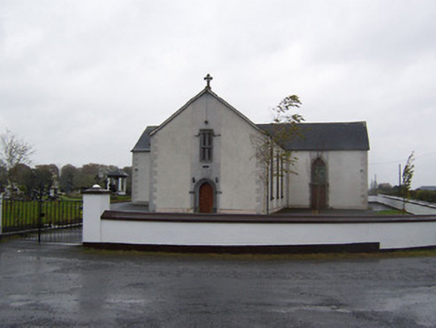 Catholic Church of the Sacred HeartChurch/chapel · 1.1 mi
Explorer Tom Catholic Church of the Sacred Heart in Meedian steals medieval stone features when nobody’s looking, then acts like…
 Fairy fort / earthen ringfort in Moorerow or TonlegeeFairy fort / earthen ringfort · 1.3 mi
Explorer Tom Fairy fort / earthen ringfort in Moorerow or Tonlegee hosted a love story next door that went badly wrong because the…
 Langan GraveyardGraveyard · 1.4 mi
Explorer Tom Langan Graveyard in County Westmeath is where the first owner’s escape plan went gloriously wrong. He dug a tunnel…
 DalystownHouse · 1.5 mi
Explorer Tom Dalystown is a farmhouse that thought it was a proper mansion, so it put on a fancy stone doorframe to prove it. It’s…
 Dunboden ParkDemesne walls/gates/railings · 1.6 mi
Explorer Tom Dunboden Park's gate is doing its best to look shy, which is weird because it's guarding a stud farm and a mausoleum.…
 Church (Site of)Church · 1.6 mi
Explorer Tom The Church in Templeoran North is basically a D-shaped burial ground with a little rectangular enclosure inside it…
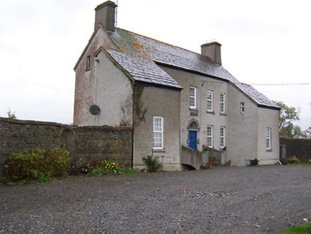 West HouseHouse · 1.7 mi
Explorer Tom West House is so tall and narrow it looks like it’s trying to sneak past the clouds to escape its neighbors. There’s a…
 Newtown Lowe GraveyardGraveyard · 4.1 mi
Explorer Tom Newtown Lowe Graveyard in County Westmeath is stuck in a feud with its neighbours over who actually owns the best view…
 Ardan WoodWood · 5.6 mi
Explorer Tom Ardan Wood, near Sonnagh in County Westmeath, has been minding its own business for centuries, which is more than I can…
More archaeology and monuments in County Westmeath · All of County Westmeath

What do you know about this place?Tap to add a comment or ask a question