
What is recorded here
From the National Monuments Service (Archaeological Survey of Ireland) record DG070-039
Places near here
Photo credits
- Maker not stated on source page, www.flickr.com
- VisionsofthePast, Wikimedia Commons · CC BY-SA 4.0
- National Inventory of Architectural Heritage
- Kenneth Allen, Geograph · CC BY-SA 2.0
- Maker not stated on source page, www.bwallpaperhd.com
- Maker not stated on source page, roaringwaterjournal.com
 Standing stone in TopsStanding stone · 608 yd
Explorer Tom Standing stone in Tops is supposedly there to determine astronomical alignments. I can’t help but picture ancient…
 Beltany Stone CircleArchaeological place · 615 yd
Explorer Tom Beltany Stone Circle stands above Raphoe like a meeting that began thousands of years ago and has decided to wait for…
 bridge867 yd
Explorer Tom Bridge in Beltany has three arches across the Deele River and V-shaped cutwaters on its piers. Built around 1790, it…
 outbuilding931 yd
Explorer Tom Outbuilding in Tops has been sitting quietly in the corner, collecting secrets and probably a few stray socks along the…
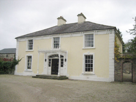 TopsHouse · 949 yd
Explorer Tom Tops in Donegal is a handsome house that seems to be having a serious falling out with its own chimney. It’s got all…
 kiln1000 yd
Explorer Tom Kiln in Tops Demesne tapers outwards towards its base like a stone ice cream cone that got stuck upside down. Built…
 Drumineney HouseHouse · 1033 yd
Explorer Tom Drumineney House would win a county fair prize for 'Most Elegant House That Hasn't Moved Since 1850' without breaking a…
 Fairy fort / ringfort in CarnowenFairy fort / ringfort · 1124 yd
Explorer Tom Fairy fort / ringfort in Carnowen is a local name and an old map mark for a large natural rock platform above the River…
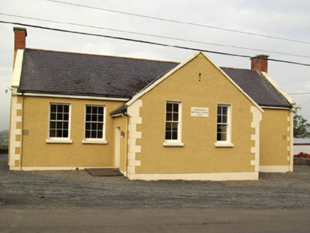 school1393 yd
Explorer Tom School in Carnowen would teach history by making you stand in the corner for three hours. It’s a T-shaped building that…
 post box1412 yd
Explorer Tom Post box in Carnowen is the smallest model from the Royal Mail, built around 1915! I wonder if King George V’s letters…
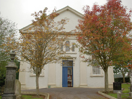 Carnowen Presbyterian ChurchChurch/chapel · 1450 yd
Explorer Tom Carnowen Presbyterian Church had a minister in 1868 earning just fifty-four quid! I bet he spent half that on tea and…
 Bullaun stone in CarnowenBullaun stone · 1557 yd
Explorer Tom Bullaun stone in Carnowen is hiding behind a pile of unuploaded paperwork! I bet it’s just too shy to show its face…
More archaeology and monuments in County Donegal · All of County Donegal

What do you know about this place?Tap to add a comment or ask a question