
Places near here
Photo credits
- kevin higgins, Wikimedia Commons · CC BY-SA 2.0
- Schcambo at English Wikipedia, Wikimedia Commons · Public domain
- The Vicious Chicken of Bristol, Wikimedia Commons · CC BY-SA 4.0
- National Inventory of Architectural Heritage
- Dedublinfan, Wikimedia Commons · CC BY-SA 4.0
- Joe King, Wikimedia Commons · CC BY-SA 3.0
- XeresNelro, Wikimedia Commons · CC BY-SA 4.0
- 1ivia, Wikimedia Commons · CC BY 2.0
- Maker named on the Wikimedia Commons picture page · CC BY-SA 2.5
Explorer Tom Goat Bench has a curse that only affects people who don't wave hello before stepping onto the little isolated platform. It’s surrounded by steep walls so you can't get out if you make a bad decision. A handy spot to stretch your legs and your imagination.
 LugnaquillaMountain / peak · 370 yd
Explorer Tom I offered Lugnaquilla a race. It offered me fog. Lugnaquilla rises to 925 metres, the highest point in Leinster, then flattens out at the top as if it has decided to put a table there. In fact the summit plateau is called Percy's Table, after an 18th century local landowner. On either side are steep glacial hollows called the North and South Prisons, names that should discourage careless wandering in mist. That broad summit can hide your way home faster than I can invent a shortcut. The mountain's dark schist cap once stuck above an ice sheet while the surrounding country lay buried; even the ice had to work around it. Routes from the Glen of Imaal and Glenmalure are serious mountain walks, with changeable weather and navigation to consider. The Glen of Imaal route passes through a military artillery range, so check firing times before setting foot there. Bring a map, proper gear and a plan for getting down. Lug may be friendly in sunshine, but it keeps the last word in fog.
The Back MotteNamed rock · 767 ydExplorer Tom The Back Motte is a named rock that would bring a bag of crisps and zero energy to any party it attended. It’s hiding behind the front one like a shy teenager at a disco. Whisper a secret at it, it's kept worse.
 CorrigasleggaunMountain / peak · 1524 yd
Explorer Tom Corrigasleggaun in County Wicklow looks like it was built by someone who really didn't read the instructions properly. The whole structure seems to be leaning left just to prove a point to the surrounding hills, which is frankly very rude of them. Spot the oldest stone and give it a name.
IndicatedEcclesiastical enclosure · 2.7 miExplorer Tom Ecclesiastical enclosure in Cullentragh Park refuses to fall down because it has a natural slope on its back and a wide ditch for defense. It’s said to be an early church site, which means it’s been listening to sermons forever. Bring a map, get lost anyway, that's the fun.
 Battle of GlenmalureMajor battlefield · 3.4 mi
Explorer Tom The Battle of Glenmalure echoes with the sound of sheep complaining about the mud in 1580. Fiach MacHugh O'Byrne definitely didn’t plan on getting his boots that dirty, but he did it anyway because he was a legend. Leave nothing but footprints and a bad pun.
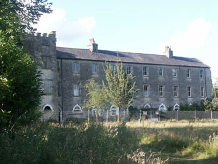 Aghavannagh BarrackBarracks · 3.7 mi
Explorer Tom Aghavannagh Barrack thinks the local rabbits are using it as their personal playground and gym. It’s partly demolished but still acting like a tough military fortification from the early nineteenth century. Tell the rabbits to keep off the roof or there will be no snacks for them.
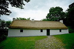 Dwyer McAllister CottageMuseum · 4.3 mi
Explorer Tom Dwyer McAllister Cottage has had so many names it should just ask people to call it 'Cottage'. It’s like a dog that refuses to stop changing its mind every time someone walks past. Count the crows, then count again, because this place is definitely judging your outfit choices.
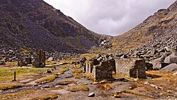 Miners' VillageRuins · 4.4 mi
Explorer Tom Miners' Village is hiding a treasure that is definitely just a rusty biscuit tin full of old buttons. The legend says it’s gold, but we all know it’s just someone’s lost lunch from 1920. It's the kind of place that makes a dull Tuesday interesting.
 GlendaloughViewpoint · 4.4 mi
Explorer Tom Glendalough is where a priest lost a bet on whether the lake would freeze, and he still owes for a pint. He’s been hiding there ever since, which explains why it looks so mysterious and full of secrets. Grand place for a sulk or a snog, your call.
 Poulanass WaterfallWaterfall · 5.4 mi
Explorer Tom Poulanass Waterfall is the shortcut that isn’t a shortcut because you’ll end up climbing over rocks for an hour just to get splashed on the face. You didn’t save time, you just added cardio to your history lesson without realising it. Bring your own legend, I've run out.
 Sessile Oak6.3 mi
Explorer Tom Sessile Oak in County Wicklow holds the unofficial world record for looking the most bored while standing perfectly still. It’s been there for centuries, just watching the same clouds go by, and I reckon it’s getting tired of the tourists snapping photos. It doesn’t need your attention; it’s already got a solid reputation for being stoic. Snap one photo, then put the phone away and actually look.
More cliffs, bays and coast in County Wicklow · All of County Wicklow

What do you know about this place?Tap to add a comment or ask a question