What is recorded here
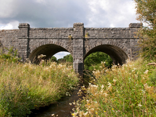
Two-arch road bridge over river, dated 1915-6; extant 1917. Tuck pointed snecked rock faced limestone walls between drag edged rock faced cut-limestone buttressed piers centred on tooled limestone ashlar triangular cutwater to pier to upriver (south) elevation having pyramidal capping with drag edged rock faced cut-limestone stringcourses supporting parapets having lichen-covered drag edged rock faced cut-limestone coping centred on benchmark-inscribed cut-limestone date stone ("1915-1916"). Pair of segmental arches with drag edged rock faced limestone ashlar voussoirs. Sited spanning Sonnagh River with unkempt grass banks to river.
A bridge erected to a design by John Joseph Noonan (b. 1879/80), County Surveyor for County Mayo North Riding (appointed 1911; dismissed 1921), representing an integral component of the early twentieth-century civil engineering heritage of the rural environs of Charlestown with the architectural value of the composition, one reconstructed 'by direct labour' retaining portions of an eighteenth-century bridge marked on the first edition of the Ordnance Survey (surveyed 1838; published 1839), confirmed not only by the robust rock faced surface finish demonstrating good quality workmanship, but also by the elegant "sweep" of the arches making a pleasing visual statement at a crossing over the Sonnagh River: meanwhile, a submerged benchmark remains of additional interest for the connections with cartography and the preparation of maps by the Ordnance Survey (established 1824).
This does not grant access. Most recorded buildings are privately owned; view them only from public ground unless the owner allows entry.
Places near here
 IndicatedFairy fort / earthen ringfort · 442 yd
 bridgebridge · 649 yd
 Enclosure in TombohollaEnclosure · 1.4 mi
 Saint Joseph's Catholic Churchchurch/chapel · 1.4 mi
 Procession Of The SoulsMemorial · 4.3 mi
 Brabazon WoodsForest · 4.3 mi
 Youth Memorial GardenMemorial · 4.7 mi
 HawthornHawthorn · 4.8 mi
 Castle (in Ruins)Castle, tower house · 6.6 mi
 Old Cave Burial GroundArchaeological place · 6.6 mi
 Thorn CaveCave · 6.9 mi
 Rath Castle in ruinsCastle, tower house · 7.9 mi
Other information
Photo: National Inventory of Architectural Heritage · Website use allowed for educational or private purposes with source credit