What is recorded here
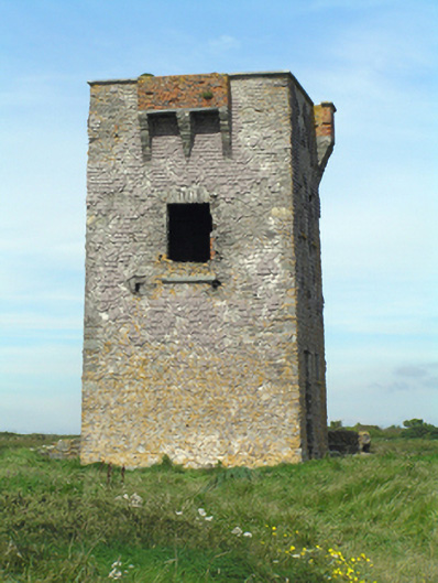
Ruinous remains of square-profile two-stage signal tower, built c. 1805, having red brick machicolation on rubble stone corbelled brackets to front (south) elevation and red brick bartizans on rubble stone corbelled brackets to north-east and north-west corners. Recent flat roof covering set within walls. Rubble stone walls with weather slating. Square-headed door opening to first floor of front elevation with rubble stone voussoirs. Square-headed window openings to east and west elevations and square-headed door opening to east elevation. Length of rubble stone boundary wall to north. Single-bay single-storey concrete look-out post, built c. 1940, to south having canted front (south) elevation. Comprising flat roof, concrete walls and square-headed openings.
One of a network of signal towers built around the south, east, and west coasts in the early nineteenth century to ensure a quick response to attempted invasion, following attempt by French fleet to land at Bantry in 1796. A remarkably complete surviving example of the typical square-plan with first floor entrance with machicolation. Nearby World War II look-out post providing interesting contrast, very different form and materials providing similar defensive and communication function.
From the Buildings of Ireland (National Inventory of Architectural Heritage) record 20907820
This does not grant access. Most recorded buildings are privately owned; view them only from public ground unless the owner allows entry.
Places near here
Enclosure in GlenawillingEnclosure · 1070 ydEnclosure in GlenawillingEnclosure · 1257 yd Capel IslandIslet · 1570 ydlighthouse1576 ydcoastguard station1.2 miBallymacoda Castle (Site of)Castle, Anglo-Norman masonry castle · 2.6 miCastle (in Ruins)Castle, tower house · 4.1 miLady's WellSpring · 4.4 miMoll Goggin's CornerMemorial · 4.5 miCaliso BayBeach / strand · 5.1 miBallycotton IslandIslet · 6.0 miWhiting BayBeach / strand · 6.4 mi
 Capel IslandIslet · 1570 yd
 lighthouse1576 yd
 coastguard station1.2 miBallymacoda Castle (Site of)Castle, Anglo-Norman masonry castle · 2.6 miCastle (in Ruins)Castle, tower house · 4.1 miLady's WellSpring · 4.4 miMoll Goggin's CornerMemorial · 4.5 mi
 Caliso BayBeach / strand · 5.1 mi
 Ballycotton IslandIslet · 6.0 mi
 Whiting BayBeach / strand · 6.4 mi
Pictures: Towel401, Wikimedia Commons · CC BY-SA 4.0; National Inventory of Architectural Heritage; john berry, Geograph · CC BY-SA 2.0; Raul Corral, Wikimedia Commons · CC BY 3.0; Oliver Dixon, Geograph · CC BY-SA 2.0
More historic places in County Cork · All of County Cork
What do you know about this place?