
Places near here
Photo credits
- National Inventory of Architectural Heritage
- Mike Searle, Geograph · CC BY-SA 2.0
- The Speckled Bird, Wikimedia Commons · CC BY-SA 4.0
- Sitomon, Wikimedia Commons · CC BY-SA 2.0
- john berry, Geograph · CC BY-SA 2.0
- Towel401, Wikimedia Commons · CC BY-SA 4.0
- Gfwc70, Wikimedia Commons · CC BY-SA 4.0
- Willow, Wikimedia Commons · CC BY 2.5
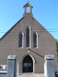 Saint Ita's Roman Catholic ChurchChurch/chapel · 63 yd
Explorer Tom Saint Ita's Roman Catholic Church in Gortaroo uses concrete imitative of stone, which is like wearing a disguise that everyone knows isn’t working. It has simple geometric forms and pointed arches that create a coherent whole, even if it’s a bit weird. Stop the car and look up, because you might miss the details.
 Inchiquin Castle (in Ruins)Castle, Anglo-Norman masonry castle · 1.1 mi
Explorer Tom Inchiquin Castle is a round tower sitting right by the river. It has a wicker-centred dome that’s mostly broken. The windows are splayed out like they’re trying to see everything. Watch out for the drawbar socket; it’s higher than your feet!
Enclosure in AghavineEnclosure · 1.5 miExplorer Tom Enclosure in Aghavine shows up as parch marks, which means it’s only visible when things are dry. It might have underground passages too! That’s spooky for a field. If the ground is wet, it’s invisible. If it’s dry, look for the weird lines!
 Burgess CottageHouse · 1.6 mi
Explorer Tom Burgess Cottage in Burges Lower is long, low, and sheltered, facing south to catch the sun like a lazy cat. It’s overgrown but retains its form, which means it’s letting nature take over while staying classy. Two lads probably bet on who could build it cheaper, and one of them lost.
 Kilnatoora CastleCastle, tower house · 3.0 mi
Explorer Tom Kilnatoora Castle started as a bet two lads made in the pub that it would stand taller than the rock face next to it. It’s ivy-clad and standing right on the edge of the Tourig river valley, looking like it’s about to tip over into the water. A handy spot to stretch your legs and your imagination, because the view is definitely better than
 Collegiate Church of Saint MaryHeritage attraction · 3.3 mi
Explorer Tom Collegiate Church of Saint Mary in County Cork took so many cups of tea to build that the builders probably never actually finished their work. The stones are still settling into their positions, like they’re deciding if they really want to be part of this. Perfect spot to practise your best tour-guide voice.
 European Yew3.4 mi
Explorer Tom European Yew in Cork says its mother-in-law designed it to be perfect, which is why it's so rigid and judgmental. She still checks up on it via the roots. Hang around long enough and you'll hear a story from a local.
 Ferry PointViewpoint · 3.9 mi
Explorer Tom Ferry Point has very strong opinions about modern buildings, thinking they’re all just tall concrete blocks lacking in soul and proper maritime history. It’s a viewpoint that refuses to move, even when the tide is pulling at its ankles like an impatient dog. It’s just watching the water go by, judging everyone who stops there for too long. Linger, it's not going anywhere and neither should you.
 Capel IslandIslet · 4.4 mi
Explorer Tom Capel Island has goats and an unfinished lighthouse, which sounds like the start of one of my more doubtful stories. Both are real. The Cork island lies off Knockadoon Head near Youghal, and the island, headland and intervening sea were protected as a nature reserve in 1985. A nineteenth-century lighthouse tower was never completed. I would offer to finish it with my toolbox, but the birds and the people caring for the reserve would prefer I leave well alone. Landing requires permission from BirdWatch Ireland; check current arrangements and sea conditions before making any plan. Otherwise enjoy it from a lawful shore viewpoint. Look for the bare tower above the island. It is one of those rare buildings whose unfinished business has become part of the view.
 Site of ChurchChurch · 4.7 mi
Explorer Tom Site of Church in Templemichael is stuck in a feud with the clouds. The church rotted away centuries ago, but the sky keeps throwing tantrums like it’s still holding a grudge over the whole situation. It's free, it's odd, what more do you want?
 Molana AbbeyHeritage attraction · 5.0 mi
Explorer Tom Molana Abbey in County Waterford is having a total meltdown on reality TV right now. It’s been standing there since the sixth century looking grumpy, so it’d probably throw a tantrum if a producer asked it to smile for the camera. Go on, count the windows and get it wrong like I did.
 European ash5.0 mi
Explorer Tom European ash in County Waterford somehow ended up in the wrong place, probably because it got confused on its way to a different forest. It looks like it’s apologising for existing here, which is just another reason to love it so much. Perfect detour when the satnav has a meltdown.
More historic places in County Cork · All of County Cork

What do you know about this place?Tap to add a comment or ask a question