Places near here
Photo credits
- P L Chadwick, Wikimedia Commons · CC BY-SA 2.0
- P L Chadwick, Geograph · CC BY-SA 2.0
- Colin Park, Geograph · CC BY-SA 2.0
- National Inventory of Architectural Heritage
- N Chadwick, Geograph · Creative Commons Attribution-ShareAlike 2.0
- dalvenjah on Flickr, Wikimedia Commons · CC BY-SA 2.0
- Mike Searle, Wikimedia Commons · CC BY-SA 2.0
,_near_Kenmare,_Co._Kerry_(geograph_5908221).jpg/250px-Bonane_Heritage_Park_-_reconstructed_crannog_(2),_near_Kenmare,_Co._Kerry_(geograph_5908221).jpg "Photo: P L Chadwick, Wikimedia Commons · CC BY-SA 2.0") CrannogHeritage attraction · 1057 yd
CrannogHeritage attraction · 1057 ydExplorer Tom Crannog is a scale model of a lake dwelling that locals swear was actually built by a giant who just wanted a quiet weekend. It’s cute, but if you tell anyone I said the giant was polite, they’ll laugh. Bring a map, get lost anyway, that's the fun.
 Bonane Heritage ParkMuseum · 1431 yd
Explorer Tom Bonane Heritage Park in Kerry has a fiddler who played all night and didn't stop until the sun came up, ruining everyone's sleep. It’s a museum of things that shouldn't have survived but did anyway because they were stubborn. Go on, count the windows and get it wrong like I did.
 KnocknamanaghMountain / peak · 3.0 mi
Explorer Tom Knocknamanagh took forty-seven cups of tea to build, according to the local lore, which explains why it looks so slightly damp all year round. The architects were clearly hydrated, but the structural integrity is questionable at best, let’s be honest about that. Stop the car, it's worth the hazard lights.
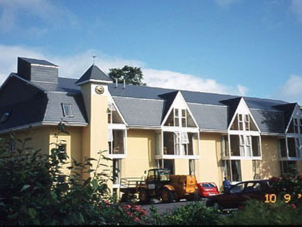 Riversdale HouseHouse · 3.4 mi
Explorer Tom Riversdale House gave up chocolate for Lent but kept its triple-gable attitude. Built in 1880, it now runs as a hotel for people who like old charm. Give it a pat on the way past, it's had a long life.
 Kenmare BridgeBridge · 3.5 mi
Explorer Tom Kenmare Bridge in Mucksna is locked in a staring contest with that one tree on the bank, and honestly, the tree is winning. The bridge just shrugs and lets the river do all the talking. It's free, it's odd, what more do you want?
 The Priests LeapViewpoint · 3.7 mi
Explorer Tom The Priests Leap in County Cork is where a terrified priest allegedly jumped his horse off a cliff to escape soldiers, landing safely in another county. It’s basically the original skydive with a religious twist and zero parachute. Look serious, nod slowly, you're basically an expert now.
 Monterey Pine3.8 mi
Explorer Tom A Monterey Pine in County Kerry claims it was friends with a famous singer who got lost here. The bird population is very skeptical about this story. Go back in winter, it's a different animal.
 Graveyard4.0 mi
Explorer Tom Graveyard in Killowen would describe the 1800s to a teenager as ‘slow Wi-Fi’. It’s still standing strong while everything else crumbles around it. Visit, then text me what you think. I'll pretend to read it.
 The Lodge WoodWood · 4.1 mi
Explorer Tom The Lodge Wood in County Kerry is refusing to fall down despite looking like it’s one strong breeze away from total collapse. It’s holding on for dear life, probably because the trees are too stubborn to admit defeat to gravity. Ten minutes here and you'll have a yarn for the pub.
 Knockboy North TopMountain / peak · 4.1 mi
Explorer Tom Knockboy North Top in County Kerry has a ridiculous smuggling story where a man tried to hide a wheelbarrow full of illegal potatoes inside its rocks. He got caught because the potatoes started growing and broke through the surface, giving away his entire secret stash instantly. Tell me if the gossip I made up is true.
_(geograph_3037291).jpg/250px-Castles_of_Munster-_Dunkerron,_Kerry_(2)_(geograph_3037291).jpg "Photo: Mike Searle, Wikimedia Commons · CC BY-SA 2.0") Dunkerron CastleCastle · 4.9 mi
Dunkerron CastleCastle · 4.9 miExplorer Tom Dunkerron Castle near Kenmare has four storeys and more changes of owner than I have excuses for being late. Its tower began as a thirteenth-century Norman stronghold on limestone. Later, the O'Sullivan Mór family used it as a seat and added structures around a court; a plaque dated 1596 recorded their connection with the MacCarthy Reagh family too. Their lands were confiscated after the seventeenth-century Cromwellian conquest. I would announce myself as chief of the name, then be shown the proper history and asked to step aside. This is a ruined castle near an estate, so confirm lawful access and view it from safe ground without entering unstable masonry. Notice how the tower and later court work together. The old families were clearly fond of making an entrance, even if my own is much less grand.
 Battle of CallannBattle · 5.7 mi
Explorer Tom Battle of Callan in Kerry suspects the postman is spying on its grave marker. Donal fell here, so it’s got a lot of pride and very little patience. Best visited with a curious kid and no timetable.
More archaeology and monuments in County Kerry · All of County Kerry

What do you know about this place?Tap to add a comment or ask a question