
Places near here
Photo credits
- National Inventory of Architectural Heritage
- DanielecDalton, Wikimedia Commons · CC BY-SA 4.0
- Mike Searle, Wikimedia Commons · CC BY-SA 2.0
- Willow, Wikimedia Commons · CC BY 2.5
- Andreas F. Borchert, Wikimedia Commons · CC BY-SA 4.0
- Sitomon, Wikimedia Commons · CC BY-SA 2.0
- ClintMalpaso, Wikimedia Commons · CC BY-SA 3.0
- Rick Crowley, Wikimedia Commons · CC BY-SA 2.0
- Sheila Russell, Wikimedia Commons · CC BY-SA 2.0
- Maigheach-gheal, Geograph · CC BY-SA 2.0
- andrew mcmillan, Wikimedia Commons · CC BY 3.0
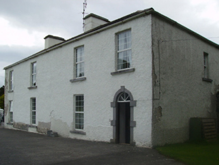 Cuillaun HouseFarm house · 1494 yd
Explorer Tom Cuillaun House in Cuillaun was written about in such bad verse that even the cows looked away. It used to be big, now it’s just a very confident fragment of a bigger idea. Tell the kids it’s a spaceship stuck in the mud.
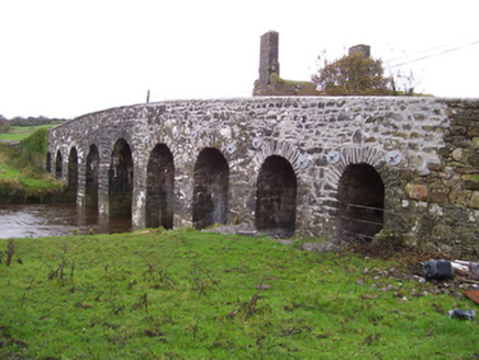 Doonmacreena BridgeBridge · 2.0 mi
Explorer Tom Doonmacreena Bridge is posing for a photo with a ruined house across the river and thinks they’re a power couple. It’s an early eighteenth-century charmer that’s been well-maintained but still acts like it’s doing you a favour. Don’t let it bully you into thinking its rough stone cutting is actually rustic charm.
 Dunmore CastleCastle · 6.7 mi
Explorer Tom Dunmore Castle had to keep updating its look while people kept trying to take it, a home improvement programme with worse neighbours than most. The de Birmingham family built a fortification by the Sinking River in the thirteenth century. Much of the surviving keep dates from the next century; later builders added extra floors, gables, windows and chimneys. It was attacked more than once before those domestic touches appeared. I would admire the new windows and politely avoid the centuries of argument around them. This is a protected ruin, so check present access, stay clear of unstable walls and respect surrounding land. From safe ground, compare the narrow older openings with the later ones. Even a defensive building eventually wanted more light and a decent fire.
 Fartamore Castle (ruins)Castle · 6.9 mi
Explorer Tom Fartamore Castle is in ruins, which means it’s officially allowed to look a bit messy without anyone complaining about the interior design choices from the seventeenth century. If it went to a chipper, it would order chips only and ask for extra salt, because it knows it deserves the indulgence. Get a photo with it before it gets a better agent.
 European ash9.4 mi
Explorer Tom European ash remembers when the builder was thinking about putting a swing here but decided against it because of the wind speed. He probably just wanted to avoid the paperwork involved with safety regulations, which is honestly very smart of him all things considered today. Tell the next person you meet it’s haunted. It might be.
 Cloigtheach (Round Tower)Round tower · 9.4 mi
Explorer Tom Cloigtheach (Round Tower) in Pollacorragune is standing guard like a very tired bouncer. It's got a high doorway because apparently nobody walks anymore. Ring your granny and tell her where you are before you get lost.
 European Yew9.7 mi
Explorer Tom European Yew remembers the priest who lost a bet there and had to walk the whole way back home barefoot. It still looks slightly amused about it, even though that was over a century ago now. Ideal spot for a dramatic phone call.
 Part of St. Jarlaths CrossCross, High cross · 11 mi
Explorer Tom Part of St. Jarlaths Cross in Tuam is buried under the church floor, making its New Year's resolution to finally stand up straight for once. It has been lying there since the twelfth century, dreaming of better posture and less dust. Whisper a secret at it, it is kept worse.
 Inis an GhaillIsland · 22 mi
Explorer Tom Inis an Ghaill has a small stone that can stop a boastful guide in mid-sentence. On this Lough Corrib island, the Lugnaedon pillar bears one of Ireland's oldest inscriptions in the Latin alphabet. Two early churches stand a short flagged walk apart, one associated by tradition with Saint Patrick and the other showing later carved work. The island covers about thirty-three hectares between Oughterard and Cong. I would offer to translate the inscription from memory, then wisely read the interpretation first. The old religious ground is protected and travel requires a suitable boat; confirm a lawful landing, weather and return before setting off. Leave the carved stone and church walls untouched. Look at the short path between the buildings. Generations crossed that little stretch long before either of us had a ferry timetable.
 Brigit's GardenVisitor attraction · 24 mi
Explorer Tom Brigit's Garden nearly became world-famous when a celebrity lost their phone here, but they blamed the Wi-Fi instead. Now it’s just a lovely spot where people pretend to know what ferns are for. Go with someone who loves old stuff and watch them melt.
 Owenriff WayWalking route · 24 mi
Explorer Tom Owenriff Way would bring a very damp towel and a grumpy attitude to any party it attended. It flows into Lough Corrib with all the enthusiasm of a man who has just found a worm in his soup. Bring a notebook and write the bit I made up.
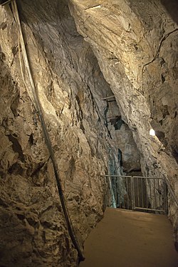 Glengowla MinesHeritage attraction · 26 mi
Explorer Tom Glengowla Mines refuses to fall down because it knows it’s got the only decent view of the local lead extraction drama. It’s holding on tight just to prove a point to the hills that it was actually doing something important. Hum something sad nearby, it adds atmosphere.
More archaeology and monuments in County Mayo · All of County Mayo

What do you know about this place?Tap to add a comment or ask a question