
What is recorded here
Research excavations were carried out in 2001 in an area directly W of the 18th-century Bantry House (CO118-075---) at the site of a deserted Gaelic medieval village and a 17th-century English settlement. Geophysical and topographic surveys had confirmed that earthworks in the area were cultural in character and a…
Read the whole record
From the National Monuments Service (Archaeological Survey of Ireland) record CO118-095
Places near here
Photo credits
- Schorle, Wikimedia Commons · CC BY-SA 3.0
- EecherplazGinkgo06.jpg : Cayambe derivative work: Ginkgotree ( talk ), Wikimedia Commons · CC BY-SA 3.0
- Maker not stated on source page, br.pinterest.com
- Andreas F. Borchert, Wikimedia Commons · CC BY-SA 4.0
- National Inventory of Architectural Heritage
- N Chadwick, Geograph · CC BY-SA 2.0
- N Chadwick, Geograph · Creative Commons Attribution-ShareAlike 2.0
- Kenneth Allen, Geograph · CC BY-SA 2.0
- Maker not stated on source page, it.pinterest.com
 Bantry HouseCountry house · 26 yd
Explorer Tom Bantry House in Seafield is showing off again with its pilasters and bay views. The Hutchinsons built it, then the Earl…
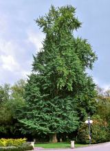 Ginkgo398 yd
Explorer Tom Another Ginkgo in County Cork, which clearly has strong opinions about your new house extension. It’s been around for…
 Abbey CemeteryCemetery · 607 yd
Explorer Tom Abbey Cemetery is waiting for a prophecy about a phoenix to rise from its headstones that never came true because the…
 Monumental PillarCross · 737 yd
Explorer Tom Monumental Pillar in Kilnaruane is a masterpiece with interlace and a boat scene that would make any sailor jealous.…
 M. EvansHouse · 952 yd
Explorer Tom M. Evans in Townlots is a Victorian showpiece on Wolfe Tone Square that would complain to the council about your…
 Saint Brendan's National SchoolSchool · 978 yd
Explorer Tom Saint Brendan's National School is posing by the harbour in Bantry. Dated 1853, it’s got those carved timber…
 Statue of Wolfe ToneMemorial · 1037 yd
Explorer Tom Statue of Wolfe Tone: Wolfe Tone’s unlikely celebrity friend was a poodle named Buster who used to nap on his lap…
 Church of Saint Brendan the Navigator (Kilmocomoge)Church/chapel · 1056 yd
Explorer Tom Church of Saint Brendan the Navigator has memorials for one family, which is either devotion or a hostage situation.…
 G.w. Biggs and CompanyStore/warehouse · 1060 yd
Explorer Tom G.W. Biggs and Company in Townlots has three carriage arches that look like they're ready for a parade. It's got raised…
 waterworks1062 yd
Explorer Tom Church of Saint John the Baptist (Site of) is wearing ogee heads like a fancy hat collection. It would say 'I have…
 Tourist OfficeVisitor information · 1087 yd
Explorer Tom Tourist Office in County Cork is secretly run by a very shaggy dog who only issues permits if you scratch him behind…
 Fairy fort / earthen ringfort in Cappanaloha WestFairy fort / earthen ringfort · 1717 yd
Explorer Tom Fairy fort / earthen ringfort in Cappanaloha West sits atop a drumlin with a field fence crossing right through the…
More archaeology and monuments in County Cork · All of County Cork

What do you know about this place?Tap to add a comment or ask a question