What is recorded here
School in Kenmare has two chimneys lined up properly and a third off to one side. Years of telling children to stand in a straight line, and the roof is up there undermining the whole operation.
On S side of Shelburne Street, Kenmare. T-shaped, one-storey structure. Front (NW) of five bays; central gabled porch projection of one bay. Gable-ended roof; three chimneys, one on each gable and one off-centre to right. Named 'National School' on 1846 OS 6-inch map. The building is still in use as such.
From the National Monuments Service (Archaeological Survey of Ireland) record KE093-061007
Places near here
Photo credits
- N Chadwick, Geograph · CC BY-SA 2.0
- National Inventory of Architectural Heritage
- Vadim Manuylov, Wikimedia Commons · CC BY-SA 3.0
- dalvenjah on Flickr, Wikimedia Commons · CC BY-SA 2.0
- P L Chadwick, Geograph · CC BY-SA 2.0
- N Chadwick, Geograph · Creative Commons Attribution-ShareAlike 2.0
- Espresso Addict, Wikimedia Commons · CC BY-SA 2.0
- Mike Searle, Wikimedia Commons · CC BY-SA 2.0
 Kenmare National SchoolSchool · 3 yd
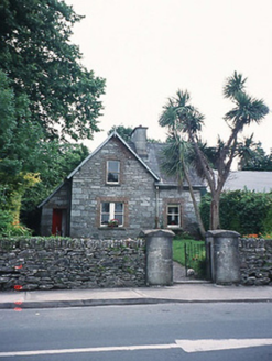 school master's house24 yd
 Cleo GalleryGallery · 58 ydKenmare Heritage Town - Main StreetMemorial · 230 yd
 Monterey Cypress298 yd
 Monterey Pine328 ydMan-made underground passage in KenmareMan-made underground passage · 349 ydKenmare Tourist Information OfficeVisitor information · 366 yd
 Kenmare Stone CircleHeritage attraction · 435 yd
 Graveyard1277 yd
 StrickeenMountain / peak · 1.5 mi
_(geograph_3037291).jpg/250px-Castles_of_Munster-_Dunkerron,_Kerry_(2)_(geograph_3037291).jpg "Photo: Mike Searle, Wikimedia Commons · CC BY-SA 2.0") Dunkerron CastleCastle · 1.7 mi
Dunkerron CastleCastle · 1.7 miMore historic places in County Kerry · All of County Kerry
What do you know about this place?Tap to add a comment or ask a question