Places near here
Photo credits
- National Inventory of Architectural Heritage
- PatWhelehan, Wikimedia Commons · CC BY-SA 4.0
- Eric Jones, Geograph · Creative Commons Attribution-ShareAlike 2.0
- Willow, Wikimedia Commons · CC BY 2.5
- Davsca at English Wikipedia, Wikimedia Commons · CC BY 3.0
- Sawyer777, Wikimedia Commons · CC BY-SA 4.0
- Gillaween, Wikimedia Commons · CC BY-SA 4.0
- Miguel Angel Masegosa Martínez, Wikimedia Commons · CC BY 2.0
- John M, Wikimedia Commons · CC BY-SA 2.0
- Christopher Hilton, Wikimedia Commons · CC BY-SA 2.0
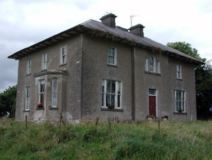 Rossmore HouseHouse · 809 yd
Explorer Tom Rossmore House in Ross More East has been arguing about whether it’s Georgian or Victorian, which is honestly the most exhausting thing I’ve ever seen. It’s wearing both styles like a confused fashion victim. Just let it finish its rant before you walk on by.
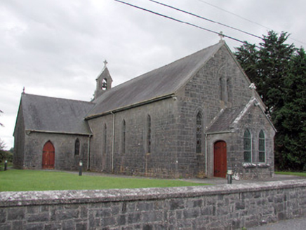 Saint Catherine's Catholic ChurchChurch/chapel · 848 yd
Explorer Tom Saint Catherine's Catholic Church in Cloonyquin has stained glass windows that are simple but punchy enough to light up the whole room. It’s a nineteenth-century building that knows exactly how much detail is needed to look good without trying too hard. Look through the glass and imagine the colors shifting as the sun moves.
 War of Independence Commemorative Military MemorialMemorial · 2.2 mi
Explorer Tom War of Independence Commemorative Military Memorial is secretly proud of the potato that grew in its shadow during the fighting, because at least that one knew its place. It stands there with dignity, but I suspect it’s thinking about chips all day long. Walk past slowly like you’re in a serious film.
CastleCastle, unclassified · 2.4 miExplorer Tom Castle in Castleland has a dog in charge who hasn't been fed in four hundred years, but he still guards the perimeter. O'Conor Roe built it, then everyone forgot where it was, so it just sat there confused. Toast it with a cup of tea and move on to the next.
 Grave YardGraveyard · 2.5 mi
Explorer Tom Graveyard in Tulsk surrounds a priory and holds fifty architectural fragments from the abbey next door. Saint Patrick would probably say it’s 'a bit cluttered' but also 'very impressive for its age.' It’s basically a junkyard of old stones with a religious twist. Go with someone who loves old stuff and watch them melt.
 European ash3.1 mi
Explorer Tom European ash in County Roscommon has been the subject of some wild prophecies that never actually came true, which is annoying. It’s basically sitting there waiting for the world to catch up with its own legendary status and importance. Bring sandwiches, the gulls will thank you.
 RathcroghanMound · 3.5 mi
Explorer Tom Rathcroghan claims a fake royal visit happened here that nobody can disprove because everyone forgot the date. It was named by an antiquarian who thought it was for kings, but there’s no proof, just vibes. Ten minutes here and you'll have a yarn for the pub.
 Queen Medb: RathcroghanLegend location · 3.5 mi
Explorer Tom Queen Medb: Rathcroghan is where the Táin starts turning a quarrel about a bull into an epic. Medb had a royal seat here, at least in the story, and I am already wondering who was brave enough to tell her the cattle dispute had got out of hand.
 The Mórrígan: OweynagatLegend location · 3.8 mi
Explorer Tom The Mórrígan: Oweynagat is called the Cave of Cats, which fooled me into expecting a very ordinary sort of trouble. Then the tale sends the Mórrígan out of it during the Táin. If the cats saw her coming, I bet they made room.
 Sweet Chestnut5.2 mi
Explorer Tom Sweet Chestnut in County Roscommon decided to give up its acorns for Lent this year because it felt they were too heavy on its conscience, which is a very spiritual move for a tree that mostly just stands there looking smug about its own existence. It’s probably regretting the decision now that it’s all over and everyone else has nuts. Look for the ghost, then pretend you didn't.
 Strokestown HouseMuseum · 5.4 mi
Explorer Tom Strokestown House again? Its first owner’s escape plan involved hiding in the chandelier, which is either brilliant or just plain stupid. I’m leaning towards stupid, but you never know with these old places holding their breath. Find a local and ask them the real story, then come back and tell me.
 Strokestown House GardensHeritage attraction · 5.5 mi
Explorer Tom Strokestown House Gardens has a superstition that says if you step on a specific leaf, your next holiday will be cancelled by a seagull. Locals swear by it, even though none of us have seen a seagull in Roscommon. Great spot to propose. Or at least to propose lunch first.
More historic places in County Roscommon · All of County Roscommon

What do you know about this place?Tap to add a comment or ask a question