About this business
From OpenStreetMap (© OpenStreetMap contributors) way 809509826
Places near here
Picture notes
- National Inventory of Architectural Heritage
- Computer-made picture. It does not show this playground.
- Kenneth Allen, Geograph · CC BY-SA 2.0
- sarah gallagher, Geograph · CC BY-SA 2.0
- Richard Webb, Geograph · CC BY-SA 2.0
- Kenneth Allen, Wikimedia Commons · CC BY-SA 2.0
- louise price, Geograph · CC BY-SA 2.0
- Somerville, Boyle T. (Henry Boyle Townshend), 1863-1936, Wikimedia Commons · Public domain
- Richard Webb, Wikimedia Commons · CC BY-SA 2.0
 The CurlewHouse · 207 yd
Explorer Tom The Curlew overlooks Mulroy Bay from a rise near Carrowkeel. Built around 1910, it has stepped red and yellow brick chimneys and wavy timber trim on the gables. Those chimneys look rather pleased to have found such a good view.
 Children's playground407 ydComputer-made picture. It does not show this playground.
Explorer Tom Children's playground in County Donegal is where lost socks go to die a dignified death. I found one there that still had my lucky charm attached to its heel.
 McGinley'sPub · 484 yd
Explorer Tom McGinley's has a guy at the bar who swears he saw a leprechaun pay his tab. He never left. Probably still in the back room polishing glasses that aren't there.
 The Village InnPub · 524 yd
Explorer Tom The Village Inn sounds like it has a village in there, but it’s just a pub. Ask the bartender if he knows the local king. He probably doesn’t.
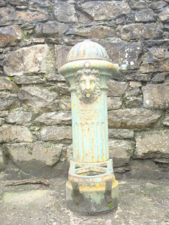 water pump582 yd
Explorer Tom Water pump in Carrowkeel has a lion's head spout and a Scottish maker's mark from Kilmarnock. The heritage survey found it out of use. I picture the little iron lion proudly guarding a vanished water job, as though retirement were someone else's idea.
 Rough IslandIslet · 1.1 mi
Explorer Tom Rough Island sits a mere fifteen metres from Murder Hole Beach. That gap is barely wider than a garden trampoline. I bet you could hop across before the tide changes your mind.
 WoodquarterForest recreation place · 1.5 mi
Explorer Tom Woodquarter's forest path follows Mulroy Bay with views toward Gull Island and Inishyweel. Coillte also records Lord Leitrim's murder here in 1878; the island views share ground with difficult local history.
 Drumfad Lower Standing StoneStanding stone · 3.1 mi
Explorer Tom This standing stone in Drumfad Lower used to stand proudly on a ridge with sweeping views of Trusk More, though it did take a tumble during a storm back in 1998. After a rescue excavation to uncover its original socket pit, it was carefully re-erected so it could keep watch over the plateau.
 Glenalla Standing StoneStanding stone · 3.7 mi
Explorer Tom Glenalla Standing Stone is squashed wider on one side than the other, like it got hugged too hard by a giant bear. I bet it’s just trying to look slim for its photos!
 Croaghan HillMountain / peak · 4.0 mi
Explorer Tom Croaghan Hill hides a passage tomb that dwarfs its own defensive walls. The enclosure is barely a metre high, yet it shelters a mound three metres high and twenty-one metres across. I bet the ancient builders felt rather small inside their own home.
 Moross CastleCastle, tower house · 4.5 mi
Explorer Tom Moross Castle was built in 1532 and sits on a tiny rocky island connected by a causeway. By 1622, someone had slapped a thatched roof on the ruins while it lay waste, which is peak medieval DIY. Only the southwest corner survives now, but that narrow causeway makes it feel like you’re walking onto a very defensive boat.
 Ballymastocker StrandViewpoint · 4.5 mi
Explorer Tom Ballymastocker Strand is a lovely viewpoint in Donegal, perfect for watching the waves crash against the rocky shore.

What do you know about this place?Tap to add a comment or ask a question