
What is recorded here
From the National Monuments Service (Archaeological Survey of Ireland) record TS045-029
Places near here
Photo credits
- National Inventory of Architectural Heritage
- Maker not stated on source page, www.interment.net
- Maker not stated on source page, old.sermitsiaq.ag
- Maker not stated on source page, en.wikipedia.org
- Maker not stated on source page, www.thestandingstone.ie
- Ahane GAA Club; individual photographer not stated, www.ahanegaa.ie
- Maker not stated on source page, readymap.irish
- No machine-readable author provided. Christian1965~commonswiki assumed (based on copyright claims)., Wikimedia Commons · Public domain
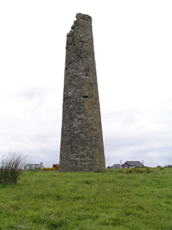 Hollyford Copper MinesChimney · 340 yd
Explorer Tom Hollyford Copper Mines has a fairy dispute over parking rights for its squat-looking chimney, which is actually quite…
 Hollyford BridgeBridge · 861 yd
Explorer Tom Hollyford Bridge gave up meat for Lent, but kept its cut stone voussoirs because they provide such pleasing textural…
 St. Joseph's CemeteryCemetery · 1264 yd
Explorer Tom St. Joseph's Cemetery is having a bit of a drama with the big oak tree next door. The roots are getting a bit too…
 Standing stone in Blackstairs,losset (toem Par.)Standing stone · 1724 yd
Explorer Tom Standing stone in Blackstairs, Losset is playing hard to get, buried in the boundary wall like a secret it doesn't want…
 Fairy fort / earthen ringfort in AughvallydeagFairy fort / earthen ringfort · 2.0 mi
Explorer Tom Fairy fort / earthen ringfort in Aughvallydeag inspired a bad poem about reeds and rain that no one wants to recite out…
 Wedge tomb in FoilyclearyWedge tomb · 3.9 mi
Explorer Tom Dermot and Granias Bed is listening to the bog whisper secrets while pretending to be a fence post. It’s a wedge tomb…
 Carrow BridgeBridge · 4.3 mi
Explorer Tom Carrow Bridge was blocked off during the war to stop Black and Tans, which sounds like a bad move if you’re trying to…
 Gowlagh BridgeBridge · 4.6 mi
Explorer Tom Gowlagh Bridge looks like a humble old step-stone but hides a massive masonry beast underneath, just waiting to show…
 Commaun BridgeBridge · 5.1 mi
Explorer Tom Commaun Bridge has seen some things, but its least favourite visitor is definitely the wind. It just howls at the…
 Mackey Park, AhaneGAA ground · 18 mi
 Monaleen GAA pitchGAA ground · 19 mi
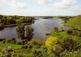 Áine and Gearóid Iarla: Lough GurLegend location · 19 mi
Explorer Tom Áine and Gearóid Iarla: Lough Gur has a goddess for the lake and a sleeping lord in the old stories. I thought I was…
More archaeology and monuments in County Tipperary · All of County Tipperary

What do you know about this place?Tap to add a comment or ask a question